Multimedia
The USGS Volcano Observatories host videos, photos, web camera views, and sometimes podcasts to share visual and audio information about volcanic eruptions and volcanic processes.
Volcano Videos and Kīlauea Livestream
Yellowstone Volcano Update Video Collection
USGS Volcano Observatories Multimedia
Check out the photos, videos, webcams, and other multimedia from the USGS Volcano Observatories.
Images
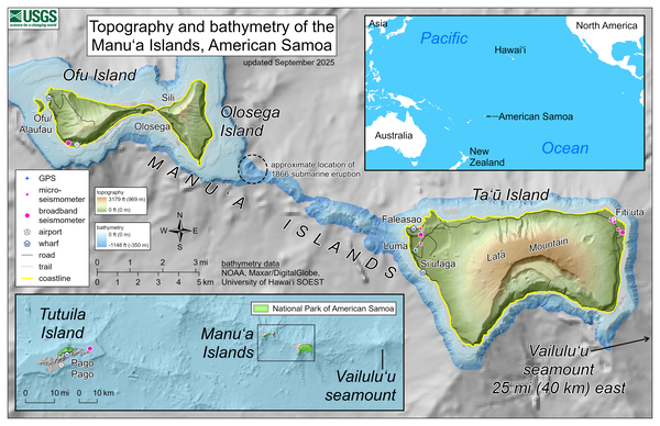
September 2025—Topography and bathymetry of the Manuʻa Islands, American Samoa
September 2025—Topography and bathymetry of the Manuʻa Islands, American SamoaThis reference map depicts the volcanoes of the Manuʻa Islands, American Samoa, which are monitored by the USGS Hawaiian Volcano Observatory.
September 2025—Topography and bathymetry of the Manuʻa Islands, American Samoa
September 2025—Topography and bathymetry of the Manuʻa Islands, American SamoaThis reference map depicts the volcanoes of the Manuʻa Islands, American Samoa, which are monitored by the USGS Hawaiian Volcano Observatory.
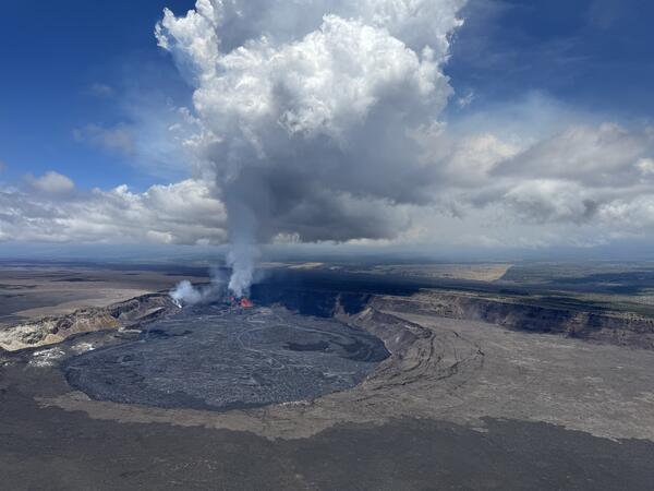
A helicopter overflight on the morning of August 6, during episode 30 of the ongoing Halema‘uma‘u eruption, provided aerial views of the lava fountaining and numerous channelized lava flows covering the crater floor. USGS photo by M. Patrick.
A helicopter overflight on the morning of August 6, during episode 30 of the ongoing Halema‘uma‘u eruption, provided aerial views of the lava fountaining and numerous channelized lava flows covering the crater floor. USGS photo by M. Patrick.
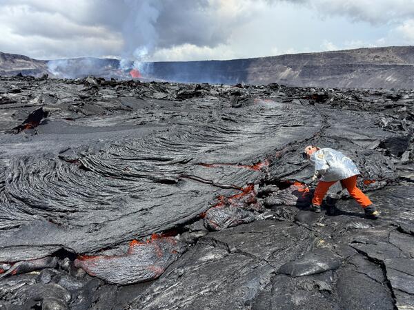
A USGS geologist collects a molten sample of the episode 30 lava flows, quenching the sample in a bucket of water. The chemistry of these lava samples is analyzed to better understand the source and storage of magma driving Hawaiian eruptions. USGS photo by M. Patrick taken on August 6, 2025.
A USGS geologist collects a molten sample of the episode 30 lava flows, quenching the sample in a bucket of water. The chemistry of these lava samples is analyzed to better understand the source and storage of magma driving Hawaiian eruptions. USGS photo by M. Patrick taken on August 6, 2025.
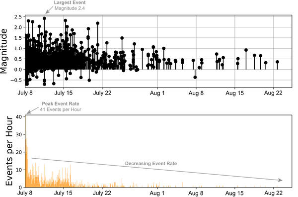
Earthquake magnitudes and numbers over time during July 8 - August 25, 2025, Mount Rainier earthquake swarm
Earthquake magnitudes and numbers over time during July 8 - August 25, 2025, Mount Rainier earthquake swarmPlots of earthquake magnitudes (top) and numbers (bottom) over the course of the July 8 - August 25, 2025 seismic swarm at Mount Rainier, Washington. The swarm was greatest in terms of numbers of events on the morning of July 8. After that time, earthquake rates slowly decreased over the course of the following days.
Hawaiian Volcano Observatory geologists captured this aerial view of Kīlauea summit on March 14, 2025, during a helicopter overflight. Three days after the end of episode 13 of the ongoing eruption, the north and south cones are degassing in the southwest corner of Halema‘uma‘u.
Hawaiian Volcano Observatory geologists captured this aerial view of Kīlauea summit on March 14, 2025, during a helicopter overflight. Three days after the end of episode 13 of the ongoing eruption, the north and south cones are degassing in the southwest corner of Halema‘uma‘u.
A wide aerial view of the summit caldera (Kaluapele) at Kīlauea volcano, showing recent lava flows (center of photo) filling the deepest portion of Halema‘uma‘u crater. The white outgassing plume from the recently active vents is carried to the southwest in the tradewinds.
A wide aerial view of the summit caldera (Kaluapele) at Kīlauea volcano, showing recent lava flows (center of photo) filling the deepest portion of Halema‘uma‘u crater. The white outgassing plume from the recently active vents is carried to the southwest in the tradewinds.
Videos
Emergency fix at a Yellowstone monitoring site (Yellowstone Monthly Update October 2025)
Emergency fix at a Yellowstone monitoring site (Yellowstone Monthly Update October 2025)The Yellowstone caldera is vast – 45 miles across by 30 miles wide. You could fit over 60 islands of Manhattan in this area. There are deep canyons, like the one on the Yellowstone River, that reveal a complex geologic history. And, forested landscapes and features remind us that this special place is ever-changing.
Lava flows in Yellowstone! (Yellowstone Monthly Update September 2025)
Lava flows in Yellowstone! (Yellowstone Monthly Update September 2025)Picture a Yellowstone eruption. What comes to mind? It’s a huge explosion, right? Like the one that formed the caldera about 631,000 years ago. But the most common form of eruption in Yellowstone isn’t a huge explosion, it’s a lava flow.
During a USGS Hawaiian Volcano Observatory helicopter overflight on the morning of August 5, geologists observed a lava pond within the north vent of the ongoing Kīlauea summit eruption. The pond was feeding a subterranean lava tube contained within the east side of the vent cone, toward the floor of Halema‘uma‘u crater.
During a USGS Hawaiian Volcano Observatory helicopter overflight on the morning of August 5, geologists observed a lava pond within the north vent of the ongoing Kīlauea summit eruption. The pond was feeding a subterranean lava tube contained within the east side of the vent cone, toward the floor of Halema‘uma‘u crater.
In this video, Cascades Volcano Observatory (CVO) scientists Tyler Paladino and Alex Iezzi and Mount Rainier National Park Geologist Scott Beason provide an update on the earthquake swarm at Mount Rainier.
In this video, Cascades Volcano Observatory (CVO) scientists Tyler Paladino and Alex Iezzi and Mount Rainier National Park Geologist Scott Beason provide an update on the earthquake swarm at Mount Rainier.
Grand Prismatic Spring: Boiling, colorful, and full of bacteria! (Yellowstone Monthly Update - July 2025)
Grand Prismatic Spring: Boiling, colorful, and full of bacteria! (Yellowstone Monthly Update - July 2025)Grand Prismatic Spring is the largest hot spring in the US, and one of the largest in the world. The boiling lake was named for the spectacular array of colors along its rim.
Yellowstone's Magma Chamber - A Hot Mess! (Yellowstone Monthly Update - June 2025)
Yellowstone's Magma Chamber - A Hot Mess! (Yellowstone Monthly Update - June 2025)There’s a lot of hot water in Yellowstone. What’s it heated by? The magma chamber beneath the surface, of course!
Yellowstone's Magma Chamber - A Hot Mess! (Yellowstone Monthly Update - June 2025)
Yellowstone's Magma Chamber - A Hot Mess! (Yellowstone Monthly Update - June 2025)There’s a lot of hot water in Yellowstone. What’s it heated by? The magma chamber beneath the surface, of course!
Audio
Lava lake activity from inside Halema`uma`u Crater
Lava lake activity from inside Halema`uma`u CraterSounds of lava lake activity within Kilauea Volcano's summit vent inside Halema`uma`u Crater on the afternoon of February 14, 2011. The continuous "crashing wave" noise is the sound of churning lava as gases are released from the lake surface, which is in nearly constant motion.
Welcome to CoreFacts, where we're always short on time and big on science. I'm Brian Campbell. Today's question is ...
How far did the ash from Mount St. Helens travel?
Welcome to CoreFacts, where we're always short on time and big on science. I'm Brian Campbell. Today's question is ...
How far did the ash from Mount St. Helens travel?
Listen to hear the answer.
Kilauea Volcano in Hawaii has experienced its first explosive eruption in more than 80 years and is now spewing noxious gas at 10 times the normal rate. John Eichelberger, head of the USGS Volcano Hazards Program, fills us in on the situation.
Kilauea Volcano in Hawaii has experienced its first explosive eruption in more than 80 years and is now spewing noxious gas at 10 times the normal rate. John Eichelberger, head of the USGS Volcano Hazards Program, fills us in on the situation.
Webcams
The camera view is north-northwest from the Biscuit Basin boardwalk looking at Black Diamond Pool, which is in the foreground (the tilted viewing angle is due to the slope of the boardwalk).
The camera view is north-northwest from the Biscuit Basin boardwalk looking at Black Diamond Pool, which is in the foreground (the tilted viewing angle is due to the slope of the boardwalk).
This static image is from a USGS Cascades Volcano Observatory research camera located at the Johnston Ridge Observatory, north of Mount St. Helens. The view is to the south. This camera is intended to assist the USGS with situational awareness. At times, clouds, rain, and snow obscure visibility.
This static image is from a USGS Cascades Volcano Observatory research camera located at the Johnston Ridge Observatory, north of Mount St. Helens. The view is to the south. This camera is intended to assist the USGS with situational awareness. At times, clouds, rain, and snow obscure visibility.
[HLcam] Live Image of Mauna Loa's northwest flank from Hualālai volcano
[HLcam] Live Image of Mauna Loa's northwest flank from Hualālai volcanoLive view of the northwest flank of Mauna Loa; the view is from the southeast flank of Hualālai [HLcam]. This camera is a pan-tilt-zoom model and the view may change depending on activity.
[MK2cam] Mauna Loa's Summit and Northeast Rift Zone from Mauna Kea
[MK2cam] Mauna Loa's Summit and Northeast Rift Zone from Mauna KeaLive Image of Mauna Loa's Summit and Northeast Rift Zone from Mauna Kea [MK2cam]. This camera is a pan-tilt-zoom model and the view may change depending on activity.
[MK2cam] Mauna Loa's Summit and Northeast Rift Zone from Mauna Kea
[MK2cam] Mauna Loa's Summit and Northeast Rift Zone from Mauna KeaLive Image of Mauna Loa's Summit and Northeast Rift Zone from Mauna Kea [MK2cam]. This camera is a pan-tilt-zoom model and the view may change depending on activity.
[V1cam] Kīlauea volcano, Hawaii (west Halemaʻumaʻu crater)
[V1cam] Kīlauea volcano, Hawaii (west Halemaʻumaʻu crater)Live view of Halemaʻumaʻu crater within Kaluapele (Kīlauea caldera), from the northwest rim of the crater [V1cam]. This camera is a pan-tilt-zoom model and the view may change depending on activity.
Disclaimer
This image is from a temporary research camera positioned just south of Puʻu ʻŌʻō, looking north at the southern flank of Puʻu ʻŌʻō's cone.
Disclaimer
This image is from a temporary research camera positioned just south of Puʻu ʻŌʻō, looking north at the southern flank of Puʻu ʻŌʻō's cone.
Disclaimer