I am trying to display a map of European river network on a Leaflet map, using as data source the EUHydro layer published by CLMS (here is the webpage, and the WMS GetCapabilities document).
Here is the code I wrote for now:
const mapOptions = {};
const map = L.map('map', mapOptions).setView([44.76, 28.10], 8);
L.tileLayer('https://tile.openstreetmap.org/{z}/{x}/{y}.png', {
maxZoom: 19,
attribution: '© <a href="http://www.openstreetmap.org/copyright">OpenStreetMap</a>',
}).addTo(map);
const EUHydroURL = 'https://image.discomap.eea.europa.eu/arcgis/services/EUHydro/EUHydro_RiverNetworkDatabase/MapServer/WMSServer?';
const wmsOptions = {
layers: '3',
format: 'image/png',
transparent: true,
version: '1.3.0',
};
const EUHydroLayer = L.tileLayer(EUHydroURL, wmsOptions).addTo(map);
console.log(EUHydroLayer);
I am new to these tools so I probably have errors in my request’s parameters.
I have tried appending service=WMS&request=GetCapabilities&version=1.3.0 to the end of the URL.
I have also tried setting up a CRS to the map with crs: L.CRS.EPSG4326 in mapOptions and wmsOptions.
As a side note, I intend to display all layers in my map, but I am just using one layer for now for testing purposes. I found the layers names from the GetCapabilities document.
-
What URL is being used, check your network tab in the browser debugger, does it return an image or an error messageIan Turton– Ian Turton2024年03月27日 09:37:07 +00:00Commented Mar 27, 2024 at 9:37
1 Answer 1
Since layer you are trying to show is not a tile layer but WMS layer, you have to use L.tileLayer.wms layer to show it. Since it has a lot of layers that are shown at different zooms, one possible strategy is to request all the layers.
This code:
var tileLayer = L.tileLayer('https://gisco-services.ec.europa.eu/maps/tiles/OSMPositronComposite/EPSG3857/{z}/{x}/{y}.png');
var wmsLayer = L.tileLayer.wms("https://image.discomap.eea.europa.eu/arcgis/services/EUHydro/EUHydro_RiverNetworkDatabase/MapServer/WMSServer", {
 version: '1.3.0',
 layers: '0,1,2,3,4,5,6,7,8,9,10,11,12,13,14,15,16,17,18,19,20',
 format: 'image/png',
 transparent: true
});

var map = L.map('map', {
 center: [41, 14],
 zoom: 4,
 layers: [tileLayer, wmsLayer]
});
gives the follwing map at zoom 4:
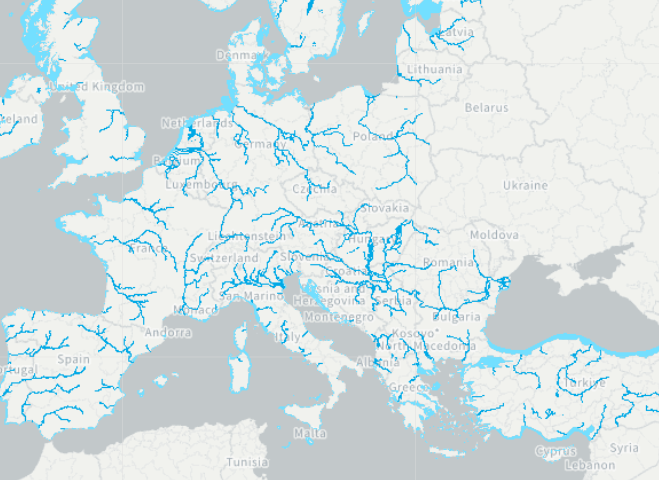
and this map at zoom 9:
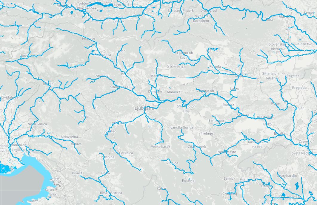
-
Thank you, indeed I was missing the
.wmssubclass, embarrassing ! Thanks also for the advice and example on requesting all the layers.tvoirand– tvoirand2024年03月27日 10:36:09 +00:00Commented Mar 27, 2024 at 10:36