Fourth update, per suggestions from comments and professor. Still getting the "takes no arguments" error "Traceback (most recent call last): File "C:\Pythonpro\pythonProject2\anothercreateschools.py", line 19, in with arcpy.da.InsertCursor(schpts, ["SHAPE@", "ID", "LONGITUDE", "LATITUDE", "NAME", "ADDRESS", "ZIP", "DISTRICT"]) as cursor: TypeError: InsertCursor() takes no arguments"
updated script
import arcpy
import fileinput
import os
wrkspce = "C:/lab11/pt2"
arcpy.env.workspace = wrkspce
arcpy.env.overwriteOutput = True
schpts = "schools.shp"
sr = arcpy.SpatialReference(102649)
sr2 = arcpy.SpatialReference("WGS 1984")
arcpy.CreateFeatureclass_management(wrkspce, schpts, "Point", spatial_reference=sr)
infi = os.path.join(wrkspce, "schools.txt")
arcpy.management.AddField(schpts,"ID")
arcpy.management.AddField(schpts,"LONGITUDE", "DOUBLE")
arcpy.management.AddField(schpts,"LATITUDE", "DOUBLE")
arcpy.management.AddField(schpts,"NAME","TEXT",field_length = 50)
arcpy.management.AddField(schpts,"ADDRESS","TEXT",field_length = 50)
arcpy.management.AddField(schpts,"ZIP","TEXT",field_length = 10)
arcpy.management.AddField(schpts,"DISTRICT")
with arcpy.da.InsertCursor(schpts, ["SHAPE@", "ID", "LONGITUDE", "LATITUDE", "NAME", "ADDRESS", "ZIP", "DISTRICT"]) as cursor:
 for line in fileinput.input(infi):
 if "ID" in line:
 continue
 else:
 mysplit = line.split(",")
 ID = (mysplit[0])
 XCoordinate = (mysplit[1])
 YCoordinate = (mysplit[2])
 NAME = (mysplit[3])
 ADDRESS = (mysplit[4])
 ZIP = (mysplit[5])
 DISTRICT = (mysplit[6])
 point = arcpy.Point(XCoordinate, YCoordinate)
 pointgeom = arcpy.PointGeometry(point, sr2)
 newRow = (pointgeom, ID, XCoordinate, YCoordinate, NAME, ADDRESS, ZIP, DISTRICT) # the number and order of values must match fields in the list you specify in the cursor
 cursor.insertRow(newRow)
Third update per my professors edits, Throwing "TypeError: InsertCursor() takes no arguments"
import arcpy
import fileinput
import os
wrkspce = "C:/lab11/pt2"
arcpy.env.workspace = wrkspce
arcpy.env.overwriteOutput = True
schpts = "schools.shp"
sr = arcpy.SpatialReference(102649)
sr2 = arcpy.SpatialReference("WGS 1984")
arcpy.CreateFeatureclass_management(wrkspce,schpts,spatial_reference=sr)
infi = os.path.join(wrkspce, "schools.txt")
arcpy.management.AddField(schpts,"ID")
arcpy.management.AddField(schpts,"NAME","TEXT",field_length = 50)
arcpy.management.AddField(schpts,"ADDRESS","TEXT",field_length = 50)
arcpy.management.AddField(schpts,"ZIP","TEXT",field_length = 10)
arcpy.management.AddField(schpts,"DISTRICT")
cursor = arcpy.da.InsertCursor(schpts,["ID","SHAPE@","LONGITUDE","LATITUDE","NAME","ADDRESS","ZIP","DISTRICT"])
with cursor:
 for line in fileinput.input(infi):
 mysplit = line.split(",")
 ID = float(mysplit[0])
 XCoordinate = float(mysplit[1])
 YCoordinate = float(mysplit[2])
 NAME = float(mysplit[3])
 ADDRESS = float(mysplit[4])
 ZIP = float(mysplit[5])
 DISTRICT = float(mysplit[6])
 point = arcpy.Point(XCoordinate, YCoordinate)
 pointgeom = arcpy.PointGeometry(point, sr2)
 newRow = (pointgeom, ID,XCoordinate,YCoordinate,NAME,ZIP,DISTRICT)
 cursor.insertRow(newRow)
 del cursor
Here is my updated script per suggestions, I am still pretty lost.
import arcpy, fileinput
wrkspce = "C:/lab11/pt2"
arcpy.env.workspace = wrkspce
arcpy.env.overwriteOutput = True
schpts = "schools.shp"
txt = "C:/lab11/pt2/schools.txt"
sr = arcpy.SpatialReference(102649)
arcpy.CreateFeatureclass_management(wrkspce,schpts,spatial_reference=sr)
#sr2 = arcpy.SpatialReference("WGS 1984") # GCS_WGS_1984, factory code 4326
cursor = arcpy.da.InsertCursor(schpts, ["SHAPE@"]) # creates an insert cursor
for line in fileinput.input(txt): # open the file
 if 'ID' in line: # if the line is the file header
 continue # do nothing and continue to next iteration
 else: # if the line is a data line
 point = arcpy.Point() # creates a point object
 ID, point.X, point.Y,NAME, ADDRESS, ZIP, DISTRICT = line.split(",") # sets point coordinates
 pointgeom = arcpy.PointGeometry(point, sr) # makes a PointGeometry
 cursor.insertRow([pointgeom]) # inserts a new row. note a row is a list [ ]
 arcpy.management.AddField(schpts, ID, "SHORT")
 arcpy.management.AddField(schpts, NAME, "TEXT", field_length=50)
 arcpy.managment.AddField(schpts, ADDRESS, "TEXT", field_length=50)
 arcpy.managment.AddField(schpts, ZIP, "TEXT", field_length=10)
 arcpy.management.AddField(schpts, DISTRICT, "SHORT")
# close the GPS file and perform clean up
fileinput.close()
del point
del pointgeom
del cursor
I am working on a lab right now and very lost on how to move forward. we need to create a shapefile from the following text file
ID,LONGITUDE,LATITUDE,NAME,ADDRESS,ZIP,DISTRICT
1,-111.585741,35.225927,Christensen Elementary School,4000 N. Cummings St,86004,9
2,-111.522826,35.269495,Cromer Elementary School,7150 E Silver Saddle Rd,86004,8
.....
Two things our professor wanted us to consider. I think I managed the first but not the second.
When you create a blank shapefile, make sure it is assigned the spatial reference of NAD 1983 SPCS for AZ Central Zone FIPS 0202. b. When you create a point geometry for a school, make sure it is assigned the spatial reference of WGS 1984.
The output shapefile must have all the attributes shown in the text file. Note that when you create a blank shapefile using the
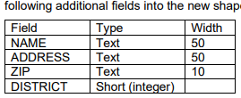
arcpy.management.CreateFeatureclass()tool, the output shapefile only has three fields: FID, Shape, and Id. You will store the school IDs in the Id field. But you must use thearcpy.management.AddField()tool to add the following additional fields into the new shapefile after creating it:
Here is the code I have so far. I do not know what more I can do.
import arcpy
import fileinput
import os
wrkspce = "C:/lab11/pt2"
arcpy.env.workspace = wrkspce
arcpy.env.overwriteOutput = True
schpts = "schools.shp"
sr = arcpy.SpatialReference(102649)
#sr2 = arcpy.SpatialReference(4356)
arcpy.CreateFeatureclass_management(wrkspce,schpts,spatial_reference=sr)
infi = os.path.join(wrkspce, "schools.txt")
arcpy.management.AddField(schpts,"ID","SHORT")
arcpy.management.AddField(schpts,"NAME","TEXT",field_length = 50)
arcpy.managment.AddField(schpts,"ADDRESS","TEXT",field_length = 50)
arcpy.managment.AddField(schpts,"ZIP","TEXT",field_length = 10)
arcpy.management.AddField(schpts,"DISTRICT","SHORT")
cursor= arcpy.da.InsertCursor(schpts,["ID","LONGITUDE","LATITUDE","NAME","ADDRESS","ZIP","DISTRICT"])
#cursor = arcpy.da.InsertCursor(schpts,"shape@XY")
for line in fileinput.input(infi):
 mysplit = line.split(",")
 ID = float(mysplit[0])
 XCoordinate = float(mysplit[1])
 YCoordinate = float(mysplit[2])
 NAME = float(mysplit[3])
 ADDRESS = float(mysplit[4])
 ZIP = float(mysplit[5])
 DISTRICT = float(mysplit[6])
 newRow = (ID,XCoordinate,YCoordinate,NAME,ZIP,DISTRICT)
 cursor.insertRow(newRow)
I know I am probably adding too many fields and some could be the ones that are in the shape file, but I do not know how to rename them and fill them in properly per the instructions.
-
You have too many code blocks here. It's extremely difficult to see what you are trying to do, much less formulate an answer.Vince– Vince2022年11月27日 21:22:00 +00:00Commented Nov 27, 2022 at 21:22
1 Answer 1
You are very close, good start.
You have point coordinates in EPSG:4326 (WGS84). You need to create a Point object from the X (LONGITUDE) and Y (LATITUDE) fields, add the Point and the appropriate SpatialReference to a PointGeometry object, then insert that geometry using the appropriate shape token (plus the other fields). Hint - it's not shape@xy (look for "geometry" in the list of shape tokens).
For bonus points, you could also specify an appropriate datum transformation to transform from WGS84 to NAD83.
Re. your first update,
# sr2 = arcpy.SpatialReference(4356)should uncommented and the correct code is4326not4356, e.g.sr2 = arcpy.SpatialReference(4326).- You are trying to add fields inside the loop. Don't. Add the fields straight after you create the featureclass, then loop.
- In your updated
arcpy.da.InsertCursoryou haven't included any of the required fields e.g["SHAPE@","NAME","ADDRESS","ZIP","DISTRICT"] - You've assigned the wrong spatial reference to the
PointGeometryit's WGS84 (i.e.sr2) - You forgot to
insertRow
Re. your 2nd update - with cursor: is wrong. Instead use:
cursor = arcpy.da.InsertCursor(schpts,["SHAPE@", "ID","LONGITUDE","LATITUDE","NAME","ADDRESS","ZIP","DISTRICT"])
for line in fileinput.input(infi):
 etc...
Note I reversed ID and shape@ above because you used that order in this line:
newRow = (pointgeom,ID,XCoordinate,YCoordinate,NAME,ZIP,DISTRICT)
-
As this is a school work question, I can't provide the code. You need to figure it out, but I will edit my answer shortly to address some issues in your update.user2856– user28562022年11月27日 03:30:23 +00:00Commented Nov 27, 2022 at 3:30
-
my professor sent me an update as well. But I keep throwing an "InsertCursor() takes no arguments, I have no idea how to rectify other than that my code is cleaner. now I can post that update as wellPieCharmer– PieCharmer2022年11月27日 03:44:23 +00:00Commented Nov 27, 2022 at 3:44
-
my professor sent another update, similar to yours, yet I am still getting this error no matter what. Traceback (most recent call last): File "C:\Pythonpro\pythonProject2\anothercreateschools.py", line 19, in <module> with arcpy.da.InsertCursor(schpts, ["SHAPE@", "ID", "LONGITUDE", "LATITUDE", "NAME", "ADDRESS", "ZIP", "DISTRICT"]) as cursor: TypeError: InsertCursor() takes no argumentsPieCharmer– PieCharmer2022年11月27日 05:40:48 +00:00Commented Nov 27, 2022 at 5:40
-
thanks again for your help. I think this is close but it still is failing, I can't find much info about the error that is being thrownPieCharmer– PieCharmer2022年11月27日 05:44:14 +00:00Commented Nov 27, 2022 at 5:44
-
1Try it without the
with(the doc examples don't usewith)user2856– user28562022年11月27日 06:39:25 +00:00Commented Nov 27, 2022 at 6:39
Explore related questions
See similar questions with these tags.