I have the NumPy array and its bounding box coordinates. I have tried to convert it into raster using rasterio, based on this answer, and it did save it as raster, but when I use rasterio.show the coordinates are very wrong.
This is the script I have used:
bbox_coords_wgs84=[-101.7359960059834, 20.21904081937658, -100.5717967351885, 20.8312118894487]
#variables for the projection:
minx=bbox_coords_wgs84[0]
maxy=bbox_coords_wgs84[3]
pixel_size= 10
#according to the post on GIS SO:
import rasterio
from rasterio.transform import from_origin
transform=from_origin(minx,maxy,pixel_size,pixel_size)
crs_img='EPSG:4326'
with rasterio.open('test1.tif',
 'w',
 driver='GTiff',
 height=ndvi.shape[0],
 width=ndvi.shape[1],
 count=1,
 dtype=ndvi.dtype,
 crs=crs_img,
 nodata=None, # change if data has nodata value
 transform=transform) as dst:
 dst.write(ndvi, 1)

#display the results:
from matplotlib import pyplot
from rasterio.plot import show
src = rasterio.open('test1.tif')
show(src)
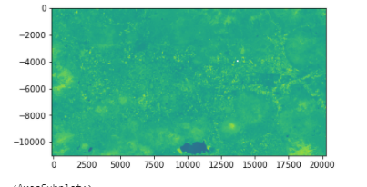
As you can see, the numbers are absolutely not the correct coordinates.
My end goal: to be able to reproject the NumPy array into WGS84 correctly.
*This post relates also to this post
1 Answer 1
You do not report that this is a suite of Reproject a NumPy array with affine transform where you use rasterio.transform.from_bounds
From rasterio.transform module
rasterio.transform.from_bounds(west, south, east, north, width, height)
Return an Affine transformation given bounds, width and height.
Return an Affine transformation for a georeferenced raster given its bounds west, south, east, north and its width and height in number of pixels.
And
rasterio.transform.from_origin(west, north, xsize, ysize)
Return an Affine transformation given upper left and pixel sizes.
Return an Affine transformation for a georeferenced raster given the coordinates of its upper left corner west, north and pixel sizes xsize, ysize.
It is not the same thing and the results are different
rasterio.transform.from_bounds( -101.7359960059834,20.21904081937658,-100.5717967351885,20.8312118894487,1103,2039)
Affine(0.0010554843796871222, 0.0, -101.7359960059834,
 0.0, -0.0003002310299519955, 20.8312118894487)
rasterio.transform.from_origin(-101.7359960059834,20.8312118894487,10,10)
Affine(10.0, 0.0, -101.7359960059834,
 0.0, -10.0, 20.8312118894487)
New
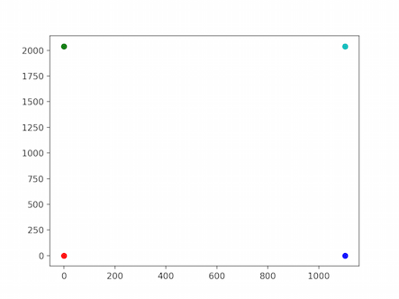
The four corners of the raster from the bound (width = 1103, height= 2039)
fig,ax = plt.subplots()
ax.plot(0,0,'ro')
ax.plot(1103,0,'bo')
ax.plot(0,2039,'go')
ax.plot(1103,2039,'co')
plt.show()
The transformation
 trans = rasterio.transform.from_bounds(-101.7359960059834,20.21904081937658-100.5717967351885,20.8312118894487,1103,2039)

trans*(0,0)
(-101.7359960059834, 20.8312118894487)
trans*(1103,0)
(-100.5717967351885, 20.8312118894487)
trans*(0,2039)
(-101.7359960059834, 20.21904081937658)
trans*(1103,2039)
(-100.5717967351885, 20.21904081937658)
fig,ax = plt.subplots()
ax.plot(*(trans*(0,0)),'ro')
ax.plot(*(trans*(1103,0)),'bo')
ax.plot(*(trans*(0,2039)),'go')
ax.plot(*(trans*(1103,2039)),'co')
plt.show()
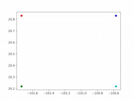
-
sorry , I feel now more confused. How can I georeference my numpy array correctly? which one should I use?ReutKeller– ReutKeller2021年01月03日 14:51:57 +00:00Commented Jan 3, 2021 at 14:51
-
rasterio.transform.from_boundsif you use boundsgene– gene2021年01月03日 14:54:22 +00:00Commented Jan 3, 2021 at 14:54 -
Explore related questions
See similar questions with these tags.
rasterio.transform.from_boundsand notrasterio.transform.from_origin