I have clarified the original question, so some of the original answers (prior to March 17 2017) will not be relevant to what I was trying to ask...
How does one add a descriptor to each line of a stacked label?
As in the following extract:
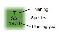
I wish to add the "Thinning", "Species" and "Planting Year" text, along with the lines pointing to each of the stacked label levels (i.e. everything to the right of the green block).
-
1What you are describing is known as stacked labels.PolyGeo– PolyGeo ♦2017年03月14日 19:04:49 +00:00Commented Mar 14, 2017 at 19:04
-
I've only now managed to get back to my desk to have a look at what has been suggested. What I'm looking to do is add a desciptor for the stacked labels (i.e. how do you add the lines and what is to the right of the lines in the picture above)Luke– Luke2017年03月16日 18:12:37 +00:00Commented Mar 16, 2017 at 18:12
-
1I think you should edit your question to make what you are asking much clearer.PolyGeo– PolyGeo ♦2017年03月16日 21:42:30 +00:00Commented Mar 16, 2017 at 21:42
-
Yeah, about that... Someone in their infinite wisdom edited both my question and title. My comment earlier today should make it sufficiently clear once again.Luke– Luke2017年03月16日 23:09:36 +00:00Commented Mar 16, 2017 at 23:09
-
1Comments do not form part of your question - they may or may not be read by potential answerers.PolyGeo– PolyGeo ♦2017年03月17日 02:13:51 +00:00Commented Mar 17, 2017 at 2:13
2 Answers 2
Open the layer's Properties, select the Label tab and click the Label Expression. Build your expression by joining the fields you want to superpose with
& vbcrlf &
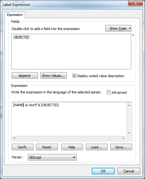
-
Hi, thanks for your answer. However it is how to add a description of what each row of the stacked labels means, rather than how to create stacked labels, that I'm looking to do. See my reply to PolyGeo above.Luke– Luke2017年03月16日 18:14:52 +00:00Commented Mar 16, 2017 at 18:14
I am unaware of a way to do exactly what you're wanting (except maybe making annotation and modifying each one to suit).
You could add test to each line. This can be done in the Label expression:
[field1] & " - Thinning" & vbcr & [field2] & " - Species" & vbcr & [field3] & " - Planting Year"
Which would output a label like:
T - Thinning
SS - Species
1970 - Planting Year
-
That is a workaround which could be useful if there's no specific way of annotating the labels as per the picture. The example picture of the annotated label which I used in the original question was taken off a map created using ArcMap, so I assumed there was a function for this. But I'm now wondering if the person who originally created it did so using another drawing program, and then inserted it into the map as an image.Luke– Luke2017年03月18日 12:25:59 +00:00Commented Mar 18, 2017 at 12:25