Error using projectRaster in R: Error in if (maxy == miny) { : missing value where TRUE/FALSE needed
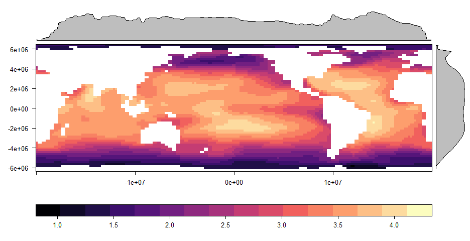
I am trying to reproject a raster from Cylindrical Equal-Area (Lambert). Central Meridian: -160. Datum: WGS 1984 to latitude and longitude But I'm getting multiple error messages. The original raster looks like this when plotted with rasterVis: enter image description here
My code is as follows:
library(raster)
#read raster
raster(r)
# Define new Proj.4 spatial reference
sr <- "+proj=longlat +datum=WGS84 +ellps=WGS84 +towgs84=0,0,0"
# Project Raster
projected_raster <- projectRaster(r, crs = sr)
#But I get the following errors:
Error in if (maxy == miny) { : missing value where TRUE/FALSE needed
In addition: Warning message:
In rgdal::rawTransform(projfrom, projto, nrow(xy), xy[, 1], xy[, :
53 projected point(s) not finite
I am not sure whether this is a problem with the raster or my code? Please help!
1 Answer 1
Error probably came from its extent.
library(raster)
r <- raster("C:/GIS/Global_Threats/Acidification/arag_500/w001001.adf")
crs(r) <- "+proj=cea +datum=WGS84 +lon_0=-160.0 +lat_ts=0.0 +x_0=0.0 +y_0=0.0"
r
r returns extent : -20037507, 19962493, -6363885, 6436115 (xmin, xmax, ymin, ymax) so just as a test I have cut y-value (latitude) at 90% to north and south.
extent(r) <- c(xmin= -20037507, xmax= 19962493, ymin= 0.9*(-6363885), ymax= 0.9*(6436115))
sr <- "+proj=longlat +datum=WGS84 +ellps=WGS84 +towgs84=0,0,0"
projected_raster <- projectRaster(r, crs= sr, method = 'bilinear')
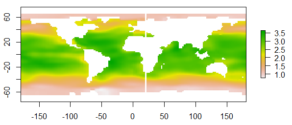
plot(projected_raster)
How much you can cut northern/southern edge will depend on your study area.
[EDIT] This discussion will be better and complete answer to your question about what happened. Re-projecting raster in R: gives warning that projected point(s) not finite?
-
I'm glad it worked out.Kazuhito– Kazuhito2016年12月08日 14:52:01 +00:00Commented Dec 8, 2016 at 14:52
Explore related questions
See similar questions with these tags.
CRSin your code: sr <- CRS("+proj=longlat +datum=WGS84 +ellps=WGS84 +towgs84=0,0,0")gdaltransform()fromgdalUtilspackage