I'm working on a pothole map web app in Google Apps Script. The map gets its data from a Google spreadsheet (from manual surveying), which is then transformed via hits to the Geolocation and Google Maps Roads APIs. There are 101 markers on the map (one marker per row of data, which represents either a pothole or a cluster of potholes). This map, for some odd reasons, takes about 20 seconds to load initially. Unacceptable!
This app makes use of the following APIs:
- jQuery
- Google Maps Roads
- Google Geolocation
- async.js
- Mustache.js
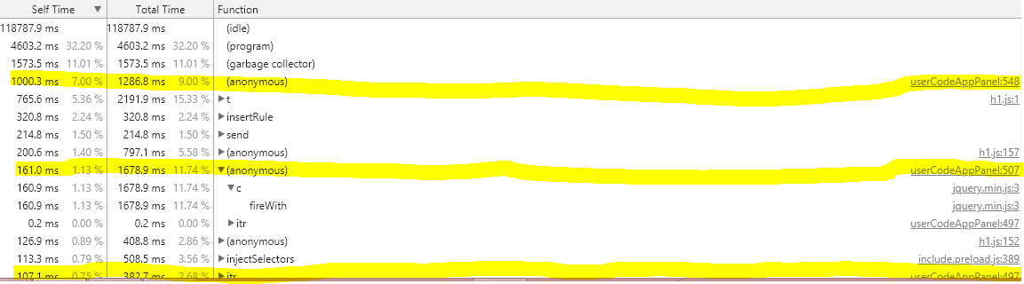
I profiled my code , and from what it seems, most of the CPU time is from methods that don't appear to be business ones. I analyzed the code profile two ways:
Self time
There were at least three heavy function calls in this respect, although nothing that seems to be too bad. enter image description here
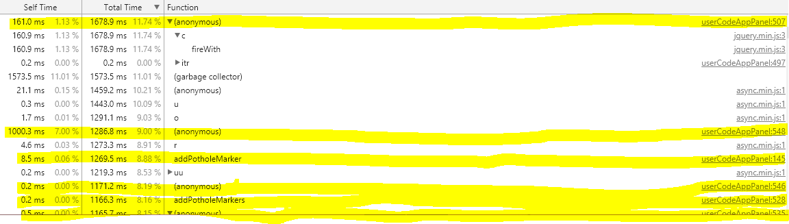
Total time
There was no business logic right at the top of this list, but plenty right below it. I present thus: enter image description here
I then identify the lines of code where these bottlenecks appear:
addPotholeMarker()
/* Adds marker to map.
 * Parameters :
 * • potholeData : a PotholeData (or PotholeDataFromCoords) object
 * • snappedToRoad: boolean
 * • callback : the function to call next (optional)
 * Returns :
 * • the marker that was added to the map, or null if arguments invalid, or callback() if it was provided
 */
function addPotholeMarker(potholeData, snappedToRoad, callback) {
 // make sure that callback is either falsy or a function
 if ((callback) && (typeof callback !== 'function')) throw new TypeError('callback specified but not a function. Thrown from addPotholeMarker()');
 // make sure potholeState is either falsy or contains iconURL string
 if ((!potholeData.potholeState) || ((potholeData.potholeState) && (potholeData.potholeState.iconURL === undefined))) throw new Error('invalid potholeData');
 // let's make sure to snap this to road if it isn't already...
 var coords = new GPSCoordinates(potholeData.lat, potholeData.lng);
 if (!snappedToRoad)
 {
 var potholeMarker = 'a garbage return value';
 getRoadCoordinates(coords).done(function(response) {
 var coords = response.snappedPoints[0].location;
 potholeData.lat = coords.latitude;
 potholeData.lng = coords.longitude;
 potholeData.isSnappedToRoad(true);
 return (potholeMarker = addPotholeMarker(potholeData, true, callback));
 /* potholeMarker = addPotholeMarker(potholeData, true);
 return potholeMarker;*/
 });
 if (callback) return callback(null);
 return;
 //return potholeMarker;
 }
 var marker = new google.maps.Marker({
 position: coords,
 title: coords.toString(),
 map: map,
 opacity: 0.5,
 icon: ((potholeData.potholeState.iconURL !== undefined) ? potholeData.potholeState.iconURL : PURPLE_MARKER)
 });
 // make marker have effect when mouseout,mouseover
 marker.addListener('mouseover', function(mouseEvent) {
 marker.setOpacity(1.0);
 });
 marker.addListener('mouseout', function(mouseEvent) {
 marker.setOpacity(0.5);
 });
 var infoWindow = createInfoWindow(potholeData);
 // save infoWindow for later reference
 infoWindows[statesMap.get(getPotholeStateFor(potholeData))].push(infoWindow);
 // on click of marker, show infoWindow
 marker.addListener('click', function(mouseEvent) {
 infoWindow.open(map, marker);
 });
 // add this to potholeMarkers
 potholeMarkers[statesMap.get(getPotholeStateFor(potholeData))].push(marker);
 if (callback) return callback(null, marker);
 return marker;
}
snapPotholeCoordsToRoad()
/* snaps potholes stored in potholeCoordinates to road
 * Parameters:
 * • potholeCollection : (Object<Array<PotholeData> >) the Collection of PotholeData to use
 * • callback : the function to call next
 */
// TODO: refactor the body of this so as to use potholeCollection (preferrably instead of potholeCoordinates)
function snapPotholeCoordsToRoad(potholeCollection, callback)
{
 var DEBUG = false;
 // guarantee that callback is function
 if ((callback) && (typeof(callback) !== 'function')) throw new TypeError('callback is something, but not a function. Thrown from snapPotholeCoordsToRoad().');
 // for each element of potholeCollection
 if (DEBUG) console.log('potholeCollection === ' + JSON.stringify(potholeCollection, null, '\t'));
 var keys = [];
 for (var key in potholeCollection)
 {
 if (typeof potholeCollection[key] !== 'function') keys.push(key);
 }
 for (var key in potholeCollection)
 {
 (function itr(k, m) {
 if (typeof potholeCollection[k] === 'function') return;
 if (m === potholeCollection[k].length) return;
 if (DEBUG) console.log('potholeCollection.' + k + '[' + m + '] == ' + JSON.stringify(potholeCollection[k][m], null, '\t'));
 // if element (PotholeData) not snapped to road
 if (!potholeCollection[k][m].isSnappedToRoad())
 {
 // get road coordinates for element
 getRoadCoordinates(potholeCollection[k][m])
 // replace element's coordinates with those road coordinates
 .done(function(newCoords) {
 potholeCollection[k][m].setCoordinates(newCoords.snappedPoints[0].location);
 //debugger;
 potholeCollection[k][m].isSnappedToRoad(true);
 if (DEBUG) console.log('potholeCollection.' + k + '[' + m + '] == ' + JSON.stringify(potholeCollection[k][m], null, '\t'));
 if ((k === keys[keys.length - 1]) && (m === potholeCollection[k].length - 1) && (callback)) return callback(null, null, potholeCollection);
 itr(k, m+1);
 })
 }
 else
 {
 if ((k === keys[keys.length - 1]) && (m === potholeCollection[k].length - 1) && (callback)) return callback(null, null, potholeCollection);
 itr(k, m+1);
 }
 })(key, 0);
 }
}
addPotholeMarkers()
/* put all potholes on the map
 * Parameters:
 * • callback : the function to call next
 * • unsnappedPotholes: (<Object<Array<PotholeData> > ) collection of potholes with coordinates that have not been snapped to road
 * • snappedPotholes : (<Object<Array<PotholeData> > ) collection of potholes with coordinates that are snapped to road
 */
function addPotholeMarkers(unsnappedPotholes, snappedPotholes, callback)
{
 var DEBUG = false;
 // guarantee that callback is function
 if ((callback) && (typeof(callback) !== 'function')) throw new TypeError('callback is something, but not a function. Thrown from addPotholeMarkers().');
 // add all the markers for them to the map
 async.waterfall([
 function(cb) {
 async.eachOf(unsnappedPotholes, function(value, key) {
 // TODO: refactor this
 async.eachOf(value, function (v, k) {
 if (DEBUG) console.log('dealing with unsnappedPotholes');
 //console.assert(v.potholeState.toString() != '[object Object]', 'toString() override missing');
 //v = revivePotholeState(v); // unnecessary, because addPotholeMarker() invokes getPotholeStateFor() to force the potholeState to be in the statesMap
 addPotholeMarker(v, false);
 })
 })
 cb(null);
 }, function(cb) {
 async.eachOf(snappedPotholes, function(value, key) {
 async.eachSeries(value, function(pothole, fn) {
 if (DEBUG) console.log('pothole == ' + JSON.stringify(pothole, null, '\t'));
 addPotholeMarker(pothole,
 true,
 //pothole.isSnappedToRoad(),
 fn);
 })
 })
 cb(null);
 }], function(err, results) {
 console.log('trying to center map');
 adjustMap();
 console.log('Map recentered');
 if (callback) {
 callback(err);
 }
 });
}
The driver function
google.script.run.withSuccessHandler(function(data) {
 async.waterfall([//fetchServerPotholeData, // for some reason, this function is not receiving data
 function(callback) {
 fetchServerPotholeData(data, callback);
 },
 fetchCoords,
 snapPotholeCoordsToRoad,
 addPotholeMarkers
 ], function(err, result) {
 if (!err) {
 console.log('Everything successfully done. Enjoy your map!');
 }
 else
 {
 console.error(err);
 }
 }
 )
}).withFailureHandler(console.log).getPotholeData();
I'm trying to fix these bottlenecks but am not sure how.
UPDATE
I'm adding a link to the GitHub project itself that I created the other day, since this question's been crickets since I asked it.
Here is the HTML code to the app (maybe the script is wasting a lot of time loading the necessary <script> tags):
<!DOCTYPE html>
<html>
<head>
<base target="_top">
<script
type="text/javascript"
src="https://maps.googleapis.com/maps/api/js?libraries=places,geocoding,geometry&key=AIzaSyCcjfkPZ0EfqZnyJrOZ3cuqdAWTFlXmFxM&callback=initMap"
async defer></script>
<script
src="//ajax.googleapis.com/ajax/libs/jquery/1.9.1/jquery.min.js">
</script>
<script src="https://cdnjs.cloudflare.com/ajax/libs/mustache.js/0.7.0/mustache.min.js"></script>
<script src="https://cdn.jsdelivr.net/npm/[email protected]/dist/async.min.js"></script>
<link rel="stylesheet" href="https://ssl.gstatic.com/docs/script/css/add-ons1.css">
<!--<script src="https://google-developers.appspot.com/_static/js/jquery-bundle.js"></script>-->
<script src="//code.jquery.com/ui/1.12.1/jquery-ui.js"></script>
<?!= include('mathFunctions'); ?>
<?!=// include('Pothole'); ?>
<?!= include('JavaScript'); ?>
<?!= include('stylesheet'); ?>
</head>
<body>
<div id="toggleHidden" class="floatingMenu">—</div>
<div id="legend" class="floatingMenu">
<span class="center row title">Legend</span>
<!-- the different icons and states of potholes -->
<div>
</div>
</div>
<div id="map">
</div>
</body>
</html>
1 Answer 1
Storing coordinates in Google Apps Script, instead of fetching each time on client-side
As was alluded to in your comment, yes the fetching of GPS coordinates could be handled on the server side.
The function getPotholesFromDataStore (or a different method) can utilize the Geocoder service. Then use the Sheet class to write the values back in the sheet.
function getPotholesFromDataStore()
{
 //doesn't change, so use const
 const POTHOLE_SPREADSHEET = 'https://docs.google.com/spreadsheets/d/1gxDeZUSykyEtL4B7WUYLeKqkDJpuc1uF02Jp_p2lfOg/edit?usp=sharing';
 //new variable for using spreadsheet for reading and then writing later
 var spreadsheet = SpreadsheetApp.openByUrl(POTHOLE_SPREADSHEET);
 //since we opened the spreadsheet above, substitute that here
 var dataStore = spreadsheet.getDataRange().getValues();
 //use this for writing later - take the first sheet (i.e. Sheet 1)
 var sheet = spreadsheet.getSheets()[0];
 //make a geocoder object and set the boundaries for Indianapolis - adjust accordingly
 var boundGeocoder = Maps.newGeocoder()
 // The latitudes and longitudes of southwest and northeast corners of Indianapolis, respectively
 .setBounds(39.635765, -86.466493, 40.042790, -85.915804);
 for (var j = 1; j < dataStore.length; j++)
 {
 // check for latitude,longitude of the pothole on the current row, using the PotholeDataHelper
 var latLngPresent = PotholeData.isValidCoord(dataStore[j][helperA.argIndices[0]], true) &&
 PotholeData.isValidCoord(dataStore[j][helperA.argIndices[1]], false);
 if (dataStore[j][3]) { //address available
 var response = boundGeocoder.geocode(dataStore[j][3]);
 if (response.results.length) {
 var result = response.results[0]; //take the first result
 var rng = sheet.getRange(j+1, 2, 1, 2);
 var values = rng.getValues();
 var valuesToSet = [[result.geometry.location.lat, result.geometry.location.lng]];
 rng.setValues(valuesToSet);
 }
}
jQuery
Since you have 5 js libraries, I would question whether jQuery is really necessary (and suggest you look at youmightnotneedjQuery.com if you haven't yet). The Fetch API or one of the three suggested on YMNNJQ could perhaps replace the jQuery AJAX code (i.e. $.ajax()).
I see places in the jQuery code like $('#legend div:first').append(). Alternatives to using that jQuery pseudo selector would be to add an id attribute to that first <div> element and using that with document.getElementById(), or select it with document.querySelector() and then use appendChild() to add the HTML.
const and let
I would definitely recommend replacing var with let and const where appropriate in the .gs files and unless browser compatibility is an issue, use it in the regular javascript files as well.
Notice in the example above, I used const POTHOLE_SPREADSHEET - this is because that value is a constant and should not be re-assigned.
const POTHOLE_SPREADSHEET = 'https://docs.google.com/spreadsheets/d/1gxDeZUSykyEtL4B7WUYLeKqkDJpuc1uF02Jp_p2lfOg/edit?usp=sharing';
-
\$\begingroup\$
letis not allowed by Google Apps Script, for some odd reason, butconstis.... \$\endgroup\$Mike Warren– Mike Warren2018年03月08日 00:14:09 +00:00Commented Mar 8, 2018 at 0:14 -
1\$\begingroup\$ doh! go figure... \$\endgroup\$2018年03月08日 00:14:42 +00:00Commented Mar 8, 2018 at 0:14
-
\$\begingroup\$ Yup, Google Apps Script is stuck in the past; /* the only reason I'm using it is because of its built-in easy-access to many things Google, for free */ \$\endgroup\$Mike Warren– Mike Warren2018年03月08日 06:46:41 +00:00Commented Mar 8, 2018 at 6:46
Explore related questions
See similar questions with these tags.
addPotholeMarker, which is invoked at most 101 * 2 == 202 times. Google Maps API documentation advises against dropping a bunch of markers all at once: developers.google.com/maps/documentation/javascript/… , at least fro adding animation (which I am not trying to do). Perhaps I could remedy that by writing a wrapperfunction(potholeData, snappedToRoad, someTime, callback) { setTimeout(addPotholeMarker(potholeData, snappedToRoad, callback), someTime) }? \$\endgroup\$