High resolution global gridded data for use in population studies
- PMID: 28140386
- PMCID: PMC5283062
- DOI: 10.1038/sdata.2017.1
High resolution global gridded data for use in population studies
Abstract
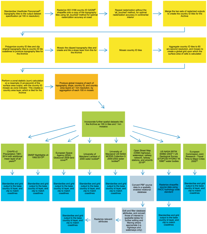
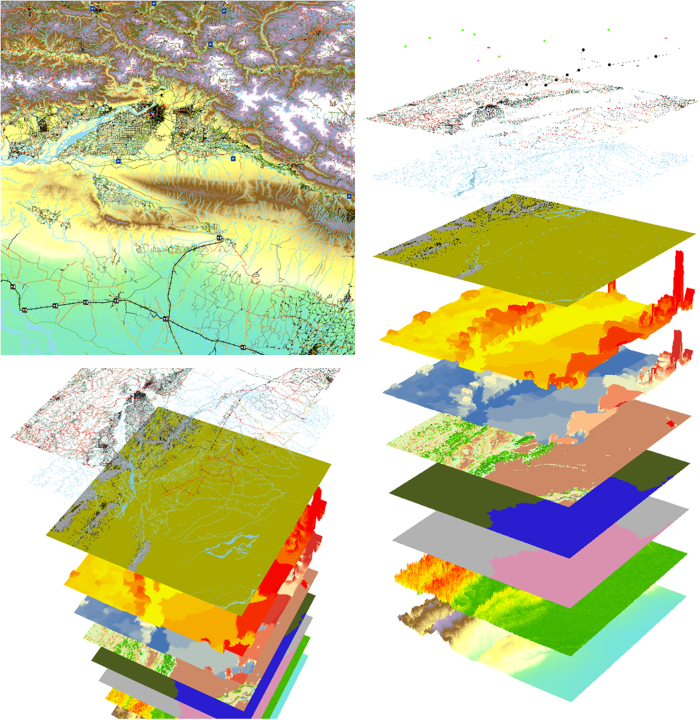
Recent years have seen substantial growth in openly available satellite and other geospatial data layers, which represent a range of metrics relevant to global human population mapping at fine spatial scales. The specifications of such data differ widely and therefore the harmonisation of data layers is a prerequisite to constructing detailed and contemporary spatial datasets which accurately describe population distributions. Such datasets are vital to measure impacts of population growth, monitor change, and plan interventions. To this end the WorldPop Project has produced an open access archive of 3 and 30 arc-second resolution gridded data. Four tiled raster datasets form the basis of the archive: (i) Viewfinder Panoramas topography clipped to Global ADMinistrative area (GADM) coastlines; (ii) a matching ISO 3166 country identification grid; (iii) country area; (iv) and slope layer. Further layers include transport networks, landcover, nightlights, precipitation, travel time to major cities, and waterways. Datasets and production methodology are here described. The archive can be downloaded both from the WorldPop Dataverse Repository and the WorldPop Project website.
Conflict of interest statement
The authors declare no competing financial interests.
Figures
References
Data Citations
-
- Sorichetta A. 2015. Harvard Dataverse. http://dx.doi.org/10.7910/DVN/PUGPVR - DOI
-
- Gaughan A. E. 2015. Harvard Dataverse. http://dx.doi.org/10.7910/DVN/8HHUDG - DOI
-
- Lloyd C. T. 2016. Harvard Dataverse. http://dx.doi.org/10.7910/DVN/ET52ON - DOI
-
- Lloyd C. T. 2016. Harvard Dataverse. http://dx.doi.org/10.7910/DVN/VKAYE8 - DOI
-
- Lloyd C. T. 2016. Harvard Dataverse. http://dx.doi.org/10.7910/DVN/BAOZPR - DOI
References
-
- United Nations. World Population Prospects: The 2015 Revision. Dept. Econ. Social Affairs, Population Div. (UNPD) http://esa.un.org/unpd/wpp/ (2015).
-
- United Nations. World Urbanization Prospects: The 2014 Revision. Highlights (ST/ESA/SER.A/352). Dept. Econ. Social Affairs, Population Div. (UNPD) http://esa.un.org/unpd/wup/Highlights/WUP2014-Highlights.pdf (2014).
-
- United Nations. World Population Prospects: The 2015 Revision. Key Findings and Advance Tables (ESA/P/WP.241). Dept. Econ. Social Affairs, Population Div. (UNPD) https://esa.un.org/unpd/wpp/publications/files/key_findings_wpp_2015.pdf (2015).
Publication types
MeSH terms
Grants and funding
LinkOut - more resources
Full Text Sources
Other Literature Sources