This site needs JavaScript to work properly. Please enable it to take advantage of the complete set of features!
Skip to main page content
U.S. flag

An official website of the United States government

Dot gov

The .gov means it’s official.
Federal government websites often end in .gov or .mil. Before sharing sensitive information, make sure you’re on a federal government site.

Https

The site is secure.
The https:// ensures that you are connecting to the official website and that any information you provide is encrypted and transmitted securely.

NIH NLM Logo
Log in
Access keys NCBI Homepage MyNCBI Homepage Main Content Main Navigation
. 2011 Feb 8;5(2):e958.
doi: 10.1371/journal.pntd.0000958.

Spatial modelling of soil-transmitted helminth infections in Kenya: a disease control planning tool

Affiliations

Spatial modelling of soil-transmitted helminth infections in Kenya: a disease control planning tool

Rachel L Pullan et al. PLoS Negl Trop Dis. .

Abstract

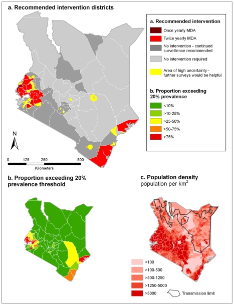
Background: Implementation of control of parasitic diseases requires accurate, contemporary maps that provide intervention recommendations at policy-relevant spatial scales. To guide control of soil transmitted helminths (STHs), maps are required of the combined prevalence of infection, indicating where this prevalence exceeds an intervention threshold of 20%. Here we present a new approach for mapping the observed prevalence of STHs, using the example of Kenya in 2009.

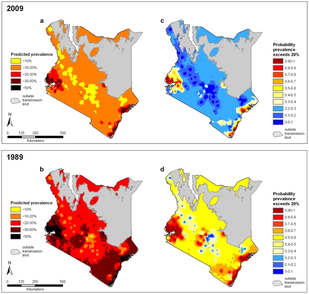
Methods and findings: Observed prevalence data for hookworm, Ascaris lumbricoides and Trichuris trichiura were assembled for 106,370 individuals from 945 cross-sectional surveys undertaken between 1974 and 2009. Ecological and climatic covariates were extracted from high-resolution satellite data and matched to survey locations. Bayesian space-time geostatistical models were developed for each species, and were used to interpolate the probability that infection prevalence exceeded the 20% threshold across the country for both 1989 and 2009. Maps for each species were integrated to estimate combined STH prevalence using the law of total probability and incorporating a correction factor to adjust for associations between species. Population census data were combined with risk models and projected to estimate the population at risk and requiring treatment in 2009. In most areas for 2009, there was high certainty that endemicity was below the 20% threshold, with areas of endemicity ≥ 20% located around the shores of Lake Victoria and on the coast. Comparison of the predicted distributions for 1989 and 2009 show how observed STH prevalence has gradually decreased over time. The model estimated that a total of 2.8 million school-age children live in districts which warrant mass treatment.

Conclusions: Bayesian space-time geostatistical models can be used to reliably estimate the combined observed prevalence of STH and suggest that a quarter of Kenya's school-aged children live in areas of high prevalence and warrant mass treatment. As control is successful in reducing infection levels, updated models can be used to refine decision making in helminth control.


Conflict of interest statement

The authors have declared that no competing interests exist.

Figures

Figure 1
Figure 1. Relationship between mean land surface temperature (LST) and prevalence of soil-transmitted helminth infection.
LST estimated from global weather station temperature records, Estimates are derived from 3,714 spatially unique cross-sectional survey locations across sub-Saharan Africa, provided by the Global Atlas of Helminth Infection (www.thiswormyworld.org). Error bars show the standard error of the mean.
Figure 2
Figure 2. Distribution of soil-transmitted helminth survey data.
Empirical prevalence of (a) combined soil-transmitted helminth, (b) A. lumbricoides, (c) T. trichiura and (d) hookworm infection from 945, cross-sectional surveys in Kenya 1974-2009. Combined prevalence was estimated calculated using a simple probabilistic model of combined infection, incorporating a small correction factor to allow for non-independence between species . Biological transmission limits were estimated using maximum land surface temperature (LST), assuming no transmission when maximum LST exceeds 40{degree}C.
Figure 3
Figure 3. Temporal random effects for hookworm, Ascaris lumbricoides and Trichuris trichiura prevalence.
Kenya from 1974–2009. Values are on a log scale (values of <0 indicate lower than average odds, values>0 indicate higher than average odds). Error bars show the 95% Bayesian Credible Intervals.
Figure 4
Figure 4. Continuous predicted combined soil-transmitted helminth (STH) prevalence and probability contour maps for Kenya.
Probability contour map shows the probability that combined STH prevalence exceeds 20%. Estimates of predicted prevalence are the mean posterior predictive values from a Bayesian space-time model for (a) 2009 and (b) 1989. The probability contour maps show the spatial distribution of probability that combined STH prevalence is >20% for (c) 2009 and (d) 1989. Biological transmission limits were estimated using maximum land surface temperature (LST), assuming no transmission when maximum LST exceeds 40{degree}C.
Figure 5
Figure 5. Control planning maps for Kenya in 2009.
(a) Recommended intervention districts for 2009, and (b) the proportion of the population for each district exceeding the prevalence threshold. Prediction locations are defined as exceeding the prevalence threshold if the probability that prevalence is ≥20% is >0.5. Recommended intervention districts are defined as: once yearly mass drug administration (MDA), at least 33% of the district exceeds 20% prevalence threshold, and twice yearly MDA, at least 33% of the district exceeds 20% prevalence threshold. Continued surveillance is recommended for districts where historically >75% of the district exceeded the 20% prevalence based on 1998 and 1988, and areas of high uncertainty are those where we can only be 50–65% certain that prevalence is lower than 20%. For reference (c) shows the distribution of population density across Kenya, using the Gridded Population of Kenya (as previously described [34]), and the biological transmission limit, estimated using maximum LST >40°C.

References

    1. Warren KS, Bundy DAP, Anderson RM, Davis AR, Henderson DA, et al. Helminth infections. In: Jamison DT, Mosley WH, Measham AR, Bobadilla JL, editors. Disease Control Priorities in Developing Countries. Oxford: Oxford University Press; 1993. pp. 131–160.
    1. Hotez PJ, Bundy DAP, Beegle K, Brooker S, Drake L, et al. Helminth Infections: soil-transmitted helminth infections and schistosomiasis. In: Jamison DT, Breman JG, Measham AR, Alleyne G, Claeson M, et al., editors. Disease Control Priorities in Developing Countries. 2 ed. New York: Oxford University Press; 2006. pp. 467–497.
    1. Guyatt HL, Brooker S, Kihamia CM, Hall A, Bundy DA. Evaluation of efficacy of school-based anthelmintic treatments against anaemia in children in the United Republic of Tanzania. Bull World Health Organ. 2001;79:695–703. - PMC - PubMed
    1. Brooker S, Kabatereine NB, Fleming AF, Devlin N. Cost and cost-effectiveness of nationwide school-based helminth control in Uganda: intra-country variation and effects of scaling-up. Health Policy Plan. 2008;23:24–35. - PMC - PubMed
    1. Hopkins DR, Eigege A, Miri ES, Gontor I, Ogah G, et al. Lymphatic filariasis elimination and schistosomiasis control in combination with onchocerciasis control in Nigeria. Am J Trop Med Hyg. 2002;67:266–272. - PubMed

Publication types

Cite

AltStyle によって変換されたページ (->オリジナル) /