Volume 378, 2018 | Understanding spatio-temporal variability of water resources and the implications for IWRM in semi-arid eastern and southern Africa
IAHS Scientific Assembly 2017, Port Elizabeth, South Africa, 10–14 July 2017
Editor(s): H. Makurira, D. Mazvimavi, J.-M. Kileshye-Onema, E. Kapangaziwiri, and W. Gumindoga
29 May 2018
Preface: Understanding spatio-temporal variability of water resources and the implications for IWRM in semi-arid eastern and southern Africa
Hodson Makurira, Dominic Mazvimavi, Evison Kapangaziwiri, Jean-Marie Kileshye Onema, and Webster Gumindoga
Proc. IAHS, 378, 1–1, https://doi.org/10.5194/piahs-378-1-2018,https://doi.org/10.5194/piahs-378-1-2018, 2018
Hydrological modelling
29 May 2018
Fuzzy and process modelling of contour ridge water dynamics
Alexander Mhizha and John Ndiritu
Proc. IAHS, 378, 3–10, https://doi.org/10.5194/piahs-378-3-2018,https://doi.org/10.5194/piahs-378-3-2018, 2018
Short summary
Short summary
Most farmers' fields do not have data on runoff while soil and rainfall characteristics differ from those experienced at fields where experiments could have been done. This study found established that information from experimental fields can be used to determine the soil moisture benefits of rainwater harvesting by contour ridges using a combination of fuzzy logic techniques and an understanding of the processes taking place. The method developed can be used to help determine suitable sites.
29 May 2018
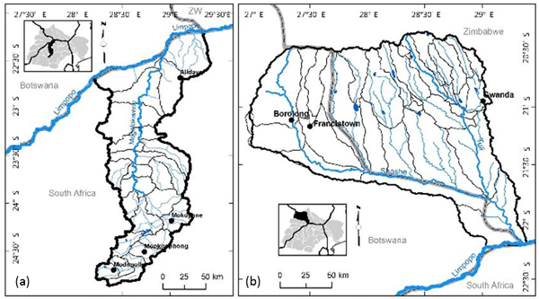
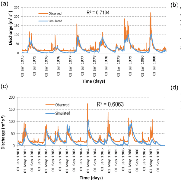
Parameter and input data uncertainty estimation for the assessment of water resources in two sub-basins of the Limpopo River Basin
Nadia Oosthuizen, Denis A. Hughes, Evison Kapangaziwiri, Jean-Marc Mwenge Kahinda, and Vuyelwa Mvandaba
Proc. IAHS, 378, 11–16, https://doi.org/10.5194/piahs-378-11-2018,https://doi.org/10.5194/piahs-378-11-2018, 2018
Short summary
Short summary
Input data (and model parameters) are significant sources of uncertainty that should be quantified. In southern Africa, water use data are among the most unreliable sources of model input data because available databases generally consist of only licensed information and actual use is generally unknown. The study assesses how uncertainty impacts the estimation of surface water resources of the Mogalakwena and Shashe sub-basins when using the databases that are currently available.
29 May 2018
Modelling of channel transmission loss processes in semi-arid catchments of southern Africa using the Pitman Model
Vuyelwa Mvandaba, Denis Hughes, Evison Kapangaziwiri, Jean-Marc Mwenge Kahinda, and Nadia Oosthuizen
Proc. IAHS, 378, 17–22, https://doi.org/10.5194/piahs-378-17-2018,https://doi.org/10.5194/piahs-378-17-2018, 2018
Short summary
Short summary
Channel transmission losses play a significant role in the water balance of the Limpopo River Basin, therefore understanding loss processes and quantifying the impact on water resources is integral for advancing knowledge and improving water resource management. Using three functions of the Pitman Model, loss simulations were conducted and results indicate that all three functions are able to simulate losses,albeit with differing magnitudes. Better quantification requires reliable observed data.
29 May 2018
Assessment of impacts of climate change on surface water availability using coupled SWAT and WEAP models: case of upper Pangani River Basin, Tanzania
Peter Kishiwa, Joel Nobert, Victor Kongo, and Preksedis Ndomba
Proc. IAHS, 378, 23–27, https://doi.org/10.5194/piahs-378-23-2018,https://doi.org/10.5194/piahs-378-23-2018, 2018
Groundwater hydrology
29 May 2018
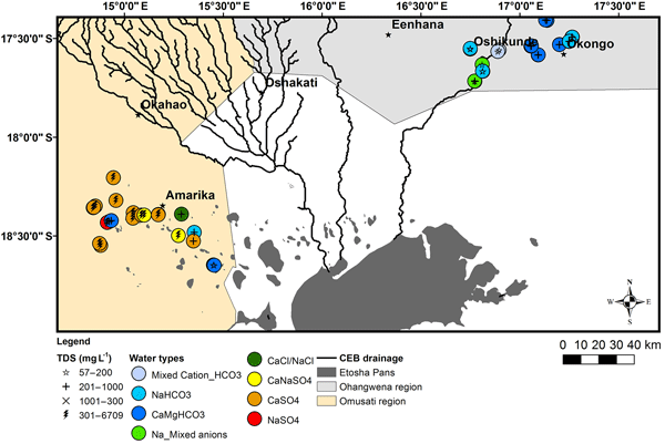
Spatio-temporal variations of hydrochemical and isotopic patterns of groundwater in hand-dug wells: the Cuvelai-Etosha Basin, Namibia
Josefina Tulimevava Hamutoko, Heike Wanke, Matthias Beyer, Marcel Gaj, and Paul Koeniger
Proc. IAHS, 378, 29–35, https://doi.org/10.5194/piahs-378-29-2018,https://doi.org/10.5194/piahs-378-29-2018, 2018
Short summary
Short summary
The key finding was that groundwater chemistry of perched aquifers is controlled by dissolution of carbonate or evaporitic minerals, silicate weathering and ion exchange and stable isotopes signify recent recharge. Spatial and temporal variations indicate that groundwater from perched aquifers are chemically different reflecting the aquifer lithologies and hydrological landscape thus groundwater management practices should always be designed taking into account these specific characteristics.
29 May 2018
Mapping groundwater availability and adequacy in the Lower Zambezi River basin
Blanca Pérez-Lapeña, Francisco Saimone, and Dinis Juizo
Proc. IAHS, 378, 37–42, https://doi.org/10.5194/piahs-378-37-2018,https://doi.org/10.5194/piahs-378-37-2018, 2018
Application of Earth Observations in hydrological assessments
29 May 2018
Impacts of landcover changes on streamflows in the Middle Zambezi Catchment within Zimbabwe
Webster Gumindoga, Hodson Makurira, and Bezel Garedondo
Proc. IAHS, 378, 43–50, https://doi.org/10.5194/piahs-378-43-2018,https://doi.org/10.5194/piahs-378-43-2018, 2018
29 May 2018
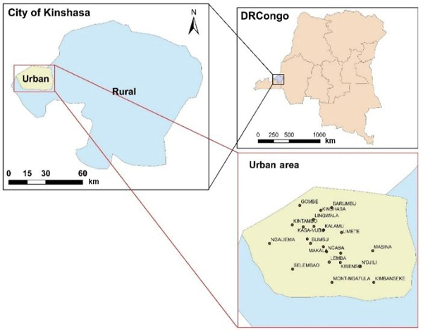
A GIS-based estimation of soil erosion parameters for soil loss potential and erosion hazard in the city of Kinshasa, the Democratic Republic of Congo
Martin Tshikeba Kabantu, Raphael Muamba Tshimanga, Jean Marie Onema Kileshye, Webster Gumindoga, and Jules Tshimpampa Beya
Proc. IAHS, 378, 51–57, https://doi.org/10.5194/piahs-378-51-2018,https://doi.org/10.5194/piahs-378-51-2018, 2018
Short summary
Short summary
This study was done in order to promote the use of remote sensing products when dealing water resources in the Congo river basin. It is the first step of a large research on the evaluation of the performance of remote sensing products on water resources modeling in the Congo river basin.
29 May 2018
Evaluation of sub daily satellite rainfall estimates through flash flood modelling in the Lower Middle Zambezi Basin
Thomas Matingo, Webster Gumindoga, and Hodson Makurira
Proc. IAHS, 378, 59–65, https://doi.org/10.5194/piahs-378-59-2018,https://doi.org/10.5194/piahs-378-59-2018, 2018
Short summary
Short summary
This paper is about evaluation of sub daily satellite rainfall estimates through flash flood modelling. The 30 minute timestep for CMORPH captures flash floods effectively and for TRMM the 3 hr timestep was the best. In general CMORPH performed better than TRMM in termsof NSE and RVE when applied to HEC-HMS model. It can be concluded that floods occur rapidly and the chances of capturing them are higher when finer resolution are applied.
Water allocation and use
29 May 2018
Optimal water resource allocation modelling in the Lowveld of Zimbabwe
Delight Mhiribidi, Joel Nobert, Webster Gumindoga, and Donald T. Rwasoka
Proc. IAHS, 378, 67–72, https://doi.org/10.5194/piahs-378-67-2018,https://doi.org/10.5194/piahs-378-67-2018, 2018
29 May 2018
Water management challenges at Mushandike irrigation scheme in Runde catchment, Zimbabwe
Jose A. Malanco, Hodson Makurira, Evans Kaseke, and Webster Gumindoga
Proc. IAHS, 378, 73–78, https://doi.org/10.5194/piahs-378-73-2018,https://doi.org/10.5194/piahs-378-73-2018, 2018
Short summary
Short summary
This study determines the actual causes of water shortage at Mushandike Irrigation Scheme in Zimbabwe. The water stress at the scheme has been largely attributed to climate change and the uncontrolled expansion of the land under irrigation. Results show that water shortages at the scheme are a result of over-abstraction from the dam beyond the firm yield, adoption of inefficient irrigation methods and high channel losses in the canal system and are not related to hydro-climatic conditions.
29 May 2018
Water use dynamics of young and mature apple trees planted in South African orchards: a case study of the Golden Delicious and Cripps' Pink cultivars
Zanele Ntshidi, Sebinasi Dzikiti, and Dominic Mazvimavi
Proc. IAHS, 378, 79–83, https://doi.org/10.5194/piahs-378-79-2018,https://doi.org/10.5194/piahs-378-79-2018, 2018
Short summary
Short summary
The aim of this study was to quantify the water requirements of young and mature unstressed apple orchards. We also assess the impact of climate variables on transpiration rates.
For mature trees, ‘Cripps’ Pink’ trees tend to use less water than ‘Golden Delicious’. This is because they tend to have more open canopies due to management practices. Transpiration was linearly related to the solar radiation, while the relationship between transpiration and VPD was non-linear.
Water quality management
29 May 2018
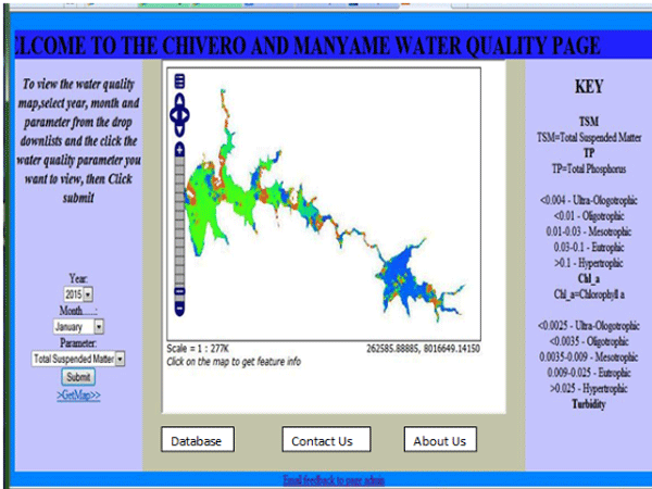
Near real time water quality monitoring of Chivero and Manyame lakes of Zimbabwe
Ronald Muchini, Webster Gumindoga, Sydney Togarepi, Tarirai Pinias Masarira, and Timothy Dube
Proc. IAHS, 378, 85–92, https://doi.org/10.5194/piahs-378-85-2018,https://doi.org/10.5194/piahs-378-85-2018, 2018
Short summary
Short summary
This paper presents an automated computer based system for determining water quality and pollution. The system results are presented in the form of a map showing the status of water at each and every point in the lake by the click of a button. A case study of Lakes Chivero and Manyame of Zimbabwe.
29 May 2018
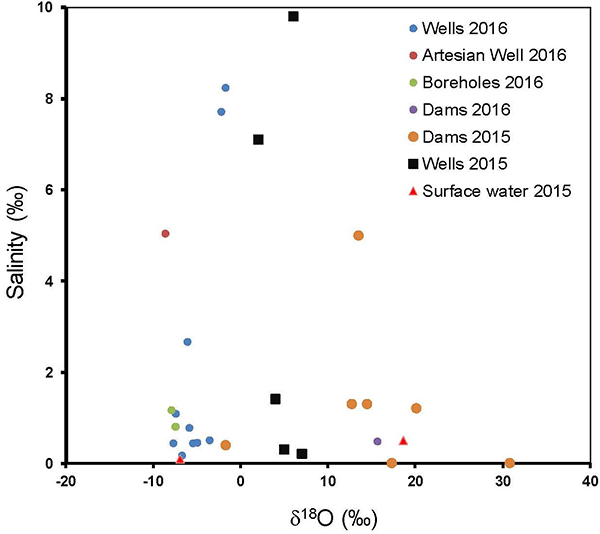
Isotopic composition and elemental concentrations in groundwater in the Kuiseb Basin and the Cuvelai-Etosha Basin, Namibia
Nnenesi A. Kgabi, Eliot Atekwana, Johanna Ithindi, Martha Uugwanga, Kay Knoeller, Lebogang Motsei, Manny Mathuthu, Gideon Kalumbu, Hilma R. Amwele, and Rian Uusizi
Proc. IAHS, 378, 93–98, https://doi.org/10.5194/piahs-378-93-2018,https://doi.org/10.5194/piahs-378-93-2018, 2018
Short summary
Short summary
High salinity in the groundwater of Cuvelai-Etosha Basin is caused by the weathering of Kalahari sediments, not the evaporation of water on surface prior to groundwater recharge. Low salinity in the Kuiseb Basin derives from rapid recharge by unevaporated rain and limited weathering of the crystalline rocks. Thus, groundwater quality in the two Basins is controlled by water-rock interaction at the surface and in the groundwater aquifer.