Volume 377, 2018 | Water quality and sediment transport issues in surface water
IAHS Scientific Assembly 2017, Port Elizabeth, South Africa, 10–14 July 2017
Editor(s): G. Mahe, K. Heal, A. B. Gupta, and H. Aksoy
Volume 377, 2018 | Water quality and sediment transport issues in surface water
IAHS Scientific Assembly 2017, Port Elizabeth, South Africa, 10–14 July 2017
Editor(s): G. Mahe, K. Heal, A. B. Gupta, and H. Aksoy
16 Apr 2018
Preface: Water quality and sediment transport issues in surface water
Gil Mahe, Kate Heal, Akhilendra B. Gupta, and Hafzullah Aksoy
Proc. IAHS, 377, 1–1, https://doi.org/10.5194/piahs-377-1-2018,https://doi.org/10.5194/piahs-377-1-2018, 2018
16 Apr 2018
A multi-approach and multi-scale study on water quantity and quality changes in the Tapajós River basin, Amazon
Rodolfo Luiz Bezerra Nóbrega, Gabriele Lamparter, Harold Hughes, Alphonce Chenjerayi Guzha, Ricardo Santos Silva Amorim, and Gerhard Gerold
Proc. IAHS, 377, 3–7, https://doi.org/10.5194/piahs-377-3-2018,https://doi.org/10.5194/piahs-377-3-2018, 2018
Short summary
Short summary
We analyzed the impacts of deforestation on water quantity and quality in the Tapajós River, one of the main tributaries of the Amazon River. To that end, we used data from 2 years of fieldwork as well other state-of-the-art techniques in small and large areas of this study area. We found changes in water quality and quantity across small and large portions of this area. Our results show that some impacts of deforestation usually observed in small streams are also affecting the major river.
16 Apr 2018
Changes in soil erosion and sediment transport based on the RUSLE model in Zhifanggou watershed, China
Lei Wang, Ju Qian, Wen-Yan Qi, Sheng-Shuang Li, and Jian-Long Chen
Proc. IAHS, 377, 9–18, https://doi.org/10.5194/piahs-377-9-2018,https://doi.org/10.5194/piahs-377-9-2018, 2018
Short summary
Short summary
By using the RUSLE model and GIS, changes of sediment yield and sediment transport were assessed in Zhifanggou watershed. The obtained results were basically consistent with the measured values. From 2000 to 2010, the amount of soil erosion was reduced yearly. The soil erosion intensity of terraced fields, sloping land and construction land were mainly very low due to soil and water conservation measures. And soil erosion increases with increasing slope in the range of 0–15°.
16 Apr 2018
Regionalising MUSLE factors for application to a data-scarce catchment
David Gwapedza, Andrew Slaughter, Denis Hughes, and Sukhmani Mantel
Proc. IAHS, 377, 19–24, https://doi.org/10.5194/piahs-377-19-2018,https://doi.org/10.5194/piahs-377-19-2018, 2018
Short summary
Short summary
The paper investigates the use of GIS to come up with model parameters. This is part of a process of simplifying model use. The findings show that existing GIS data can be used for estimating model parameters as the outcomes of the research show that model outputs are consistent with previously estimated measures. This research is part of a development of a model which can estimate soil loss and sediment delivery at broad spatial and temporal scales to improve catchment management.
16 Apr 2018
Water quality modelling of an impacted semi-arid catchment using flow data from the WEAP model
Andrew R. Slaughter and Sukhmani K. Mantel
Proc. IAHS, 377, 25–33, https://doi.org/10.5194/piahs-377-25-2018,https://doi.org/10.5194/piahs-377-25-2018, 2018
Short summary
Short summary
WQSAM is a water quality model designed specifically for South Africa as it relies on flow data generated by South African-specific flow models. However, many of the characteristics of WQSAM would make it suitable for other developing semi-arid countries. This study attempted to adapt WQSAM to take in flow data from the globally-applied WEAP flow model so that WQSAM can be applied elsewhere. WQSAM could effectively use the flow data from the WEAP model as demonstrated on a case-study catchment.
16 Apr 2018
Estimation of sediment deposits in the Ghézala reservoir in northern Tunisia
Majid Mathlouthi and Fethi Lebdi
Proc. IAHS, 377, 35–40, https://doi.org/10.5194/piahs-377-35-2018,https://doi.org/10.5194/piahs-377-35-2018, 2018
Short summary
Short summary
The control of sedimentation in a reservoir provides a global evaluation of the process of erosion and transportation of sediment. Knowledge of sedimentation is useful for reservoir management. Bathymetric surveys can be used to assess the silting volume of dams. The results of two surveys of the Ghézala dam reservoir in northern Tunisia are available. The measurements provide initial information about the quantity and variability of silting and the mechanism of sediment deposition.
16 Apr 2018
Morphodynamic change analysis of bedforms in the Lower Orinoco River, Venezuela
Santiago Paul Yepez, Alain Laraque, Carlo Gualtieri, Frédéric Christophoul, Claudio Marchan, Bartolo Castellanos, Jose Manuel Azocar, Jose Luis Lopez, and Juan Alfonso
Proc. IAHS, 377, 41–50, https://doi.org/10.5194/piahs-377-41-2018,https://doi.org/10.5194/piahs-377-41-2018, 2018
Short summary
Short summary
Enhancing knowledge of the role of morphological changes (volume) with this new methodology is an opportunity to gain better understanding of river bed sediment transport. This type of study will support dredging projects in the Orinoco River to maintain navigability, which will contribute to the management of this important river basin.
16 Apr 2018
Morphodynamic simulation of sediment deposition patterns on a recently stripped bedrock anastomosed channel
David Milan, George Heritage, Neil Entwistle, and Stephen Tooth
Proc. IAHS, 377, 51–56, https://doi.org/10.5194/piahs-377-51-2018,https://doi.org/10.5194/piahs-377-51-2018, 2018
Short summary
Short summary
We present 2D morphodynamic simulations of hydraulics and sediment deposition patterns over an exposed bedrock anastomosed pavement. Alluvial barforms appear to be initiated through sediment deposition in bedrock topographic lows. It is likely that vegetation establishment in these depositional loci increases the cohesive strength of the deposited sediment and captures additional sediment and propagules, eventually leading to greatest thicknesses of alluvium positioned over the bedrock lows.
16 Apr 2018
Sedimentation and Its Impacts/Effects on River System and Reservoir Water Quality: case Study of Mazowe Catchment, Zimbabwe
Colleta Tundu, Michael James Tumbare, and Jean-Marie Kileshye Onema
Proc. IAHS, 377, 57–66, https://doi.org/10.5194/piahs-377-57-2018,https://doi.org/10.5194/piahs-377-57-2018, 2018
Short summary
Short summary
Soil erosion result in the deposition of sediments into rivers and reservoirs. The sediments affect the water quality resulting in the treatment of the water being expensive. The sediments that are carried into the reservoir reduces the capacity of the dam. The reduction of water quality in Chimhanda dam as well as the increase in the cost of treatment of the water pushed the author to do a research.
16 Apr 2018
Etude de l'impact des barrages sur la réduction des transports sédimentaires jusqu'à la mer par approche paléohydrologique dans la basse vallée de la Medjerda
Fatma Kotti, Laurent Dezileau, Gil Mahé, Hamadi Habaieb, Malik Bentkaya, Claudine Dieulin, and Oula Amrouni
Proc. IAHS, 377, 67–76, https://doi.org/10.5194/piahs-377-67-2018,https://doi.org/10.5194/piahs-377-67-2018, 2018
Short summary
Short summary
This study was designed to prove that the coastal changes of the Gulf of Tunis are mainly driven by the changes of the hydrological regime of the Medjerda river due to dams. We sampled cores of sediments in the low valley just before the sea, and analyzed them. They show the dramatic reduction of sediment supply after 1981, date of construction of the largest dam of Sidi Salem, and the disappearance of sand in the fluvial sediments.
16 Apr 2018
The sedimentological changes caused by human impact at the artificial channel of Medjerda-River (Coastal zone of Medjerda, Tunisia)
Thouraya Benmoussa, Oula Amrouni, Laurent Dezileau, Gil Mahé, and Saâdi Abdeljaouad
Proc. IAHS, 377, 77–81, https://doi.org/10.5194/piahs-377-77-2018,https://doi.org/10.5194/piahs-377-77-2018, 2018
16 Apr 2018
Satellite images survey for the identification of the coastal sedimentary system changes and associated vulnerability along the western bay of the Gulf of Tunis (northern Africa)
Abderraouf Hzami, Oula Amrouni, Gheorghe Romanescu, Cristian Constantin Stoleriu, Alin Mihu-Pintilie, and Abdeljaouad Saâdi
Proc. IAHS, 377, 83–89, https://doi.org/10.5194/piahs-377-83-2018,https://doi.org/10.5194/piahs-377-83-2018, 2018
Short summary
Short summary
The aim of this study consists in testing the effectiveness of satellite data in order to monitoring shoreline and sedimentary features changes, especially the rapidly changing of Gulf of Tunis coast. The study area is located in the Gulf of Tunis western bay (Southern Mediterranean Sea) which is characterized by sandy beaches of Ghar Melah and Raoued (Medjerda Delta area). The aerial photographs and satellite imageries were 15 used for mapping the evolution of shoreline. Diachronic data.
16 Apr 2018
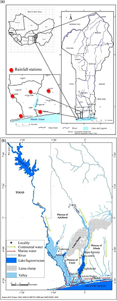
Sedimentary evolution and ecosystem change in Ahémé lake, south-west Benin
Ernest Amoussou, Henri S. Totin Vodounon, Expédit W. Vissin, Gil Mahé, and Marc Lucien Oyédé
Proc. IAHS, 377, 91–96, https://doi.org/10.5194/piahs-377-91-2018,https://doi.org/10.5194/piahs-377-91-2018, 2018