Gunalda
Download coordinates as:
| Gunalda Queensland | |
|---|---|
| Gunalda Hotel | |
Gunalda is located in Queensland Gunalda Gunalda | |
| Coordinates | 25°59′40′′S 152°33′41′′E / 25.9944°S 152.5613°E / -25.9944; 152.5613 (Gunalda (town centre)) |
| Population | 426 (2021 census)[1] |
| • Density | 6.330/km2 (16.394/sq mi) |
| Postcode(s) | 4570 |
| Area | 67.3 km2 (26.0 sq mi) |
| Time zone | AEST (UTC+10:00) |
| Location | |
| LGA(s) | |
| State electorate(s) | Gympie |
| Federal division(s) | Wide Bay |
|
Localities around Gunalda: Scotchy Pocket
Gunalda
Anderleigh
| |
Gunalda is a rural town in the Gympie Region and a locality split between Gympie Region and Fraser Coast Region in Queensland, Australia.[2] [3] [4] In the 2021 census, the locality of Gunalda had a population of 426 people.[1]
Geography
[edit ]The town is 196 kilometres (122 mi) from the state capital, Brisbane.
The Bruce Highway runs through from south-west to north.[5]
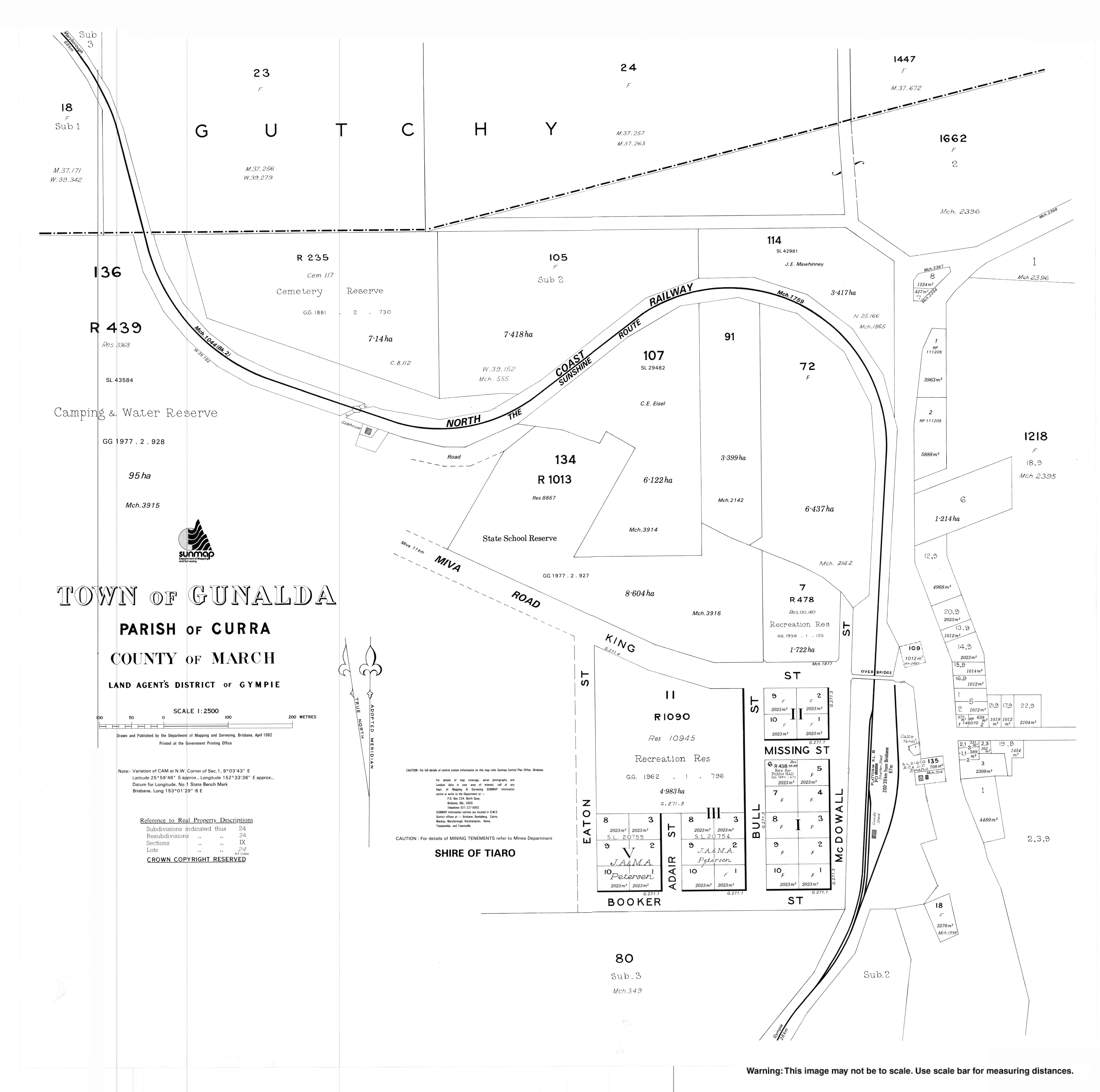
The North Coast railway line enters the locality from the south-west (Curra) and passes to the west of the town and exists to the north-west (Theebine).[6] Previously the railway line passed through the town,[7] which was served by the now-dismantled Gunalda railway station (25°59′39′′S 152°33′43′′E / 25.9943°S 152.5620°E / -25.9943; 152.5620 (Gunalda railway station) ).[8]
History
[edit ]Thompson's Flat Provisional School opened on 8 August 1881. In 1889, the school was renamed Gunalda Provisional School. On 1 January 1909, it became Gunalda State School.[9]
Eaton Post Office opened on 1 September 1882 and was renamed Gunalda in 1883.[10]
The town was originally called Keelar but after the railway station was named Gunalda on 2 November 1923, the town was renamed Gunalda.[2]
In December 1938, the foundation stone was laid for a Catholic church. On Sunday 8 October 1939, Archbishop James Duhig officially opened and dedicated the Catholic Church of the Little Flower.[11]
In 1947, Christ Church Anglican was relocated from Munna Creek to 11 King Street (25°59′36′′S 152°33′41′′E / 25.9934°S 152.5613°E / -25.9934; 152.5613 (Christ Church Anglican) ) in Gunalda where it retained the name Christ Church Anglican.[12] [13]
Demographics
[edit ]In the 2006 census, the locality of Gunalda and the surrounding area had a population of 574 people.[14]
In the 2016 census, the locality of Gunalda had a population of 392 people.[15]
In the 2021 census, the locality of Gunalda had a population of 426 people.[1]
Education
[edit ]Gunalda State School is a government primary (Prep-6) school for boys and girls at King Street (25°59′34′′S 152°33′37′′E / 25.9927°S 152.5604°E / -25.9927; 152.5604 (Gunalda State School) ).[16] [17] In 2018, the school had an enrolment of 35 students with 3 teachers (2 full-time equivalent) and 5 non-teaching staff (3 full-time equivalent).[18]
There are no secondary schools in Gunalda. The nearest government secondary school is James Nash State High School in Gympie to the south-east.[6]
Facilities
[edit ]Gunalda Cemetery is on the western end of Cotter Drive (25°59′15′′S 152°33′19′′E / 25.9875°S 152.5553°E / -25.9875; 152.5553 (Gunalda Cemetery) ).[19]
References
[edit ]
- ^ a b c Australian Bureau of Statistics (28 June 2022). "Gunalda (SAL)". 2021 Census QuickStats. Retrieved 28 February 2023. Edit this at Wikidata
- ^ a b "Gunalda – town in Gympie Region (entry 15054)". Queensland Place Names. Queensland Government . Retrieved 21 June 2017.
- ^ "Gunalda – locality in Gympie Region (entry 49520)". Queensland Place Names. Queensland Government . Retrieved 21 June 2017.
- ^ "Gunalda – locality in the Fraser Coast Region (entry 46740)". Queensland Place Names. Queensland Government . Retrieved 21 June 2017.
- ^ "Gunalda, Queensland" (Map). Google Maps . Retrieved 20 August 2021.
- ^ a b "Queensland Globe". State of Queensland . Retrieved 19 June 2022.
- ^ "Town of Gunalda" (Map). Queensland Government. 1982. Archived from the original on 20 June 2022. Retrieved 20 June 2022.
- ^ "Railway stations and sidings - Queensland". Queensland Open Data. Queensland Government. 2 October 2020. Archived from the original on 5 October 2020. Retrieved 5 October 2020.
- ^ Queensland Family History Society (2010), Queensland schools past and present (Version 1.01 ed.), Queensland Family History Society, ISBN 978-1-921171-26-0
- ^ Premier Postal History. "Post Office List". Premier Postal Auctions. Archived from the original on 15 May 2014. Retrieved 10 May 2014.
- ^ "NEW CHURCH AT GUNALDA". Maryborough Chronicle, Wide Bay and Burnett Advertiser . No. 21, 182. Queensland, Australia. 30 September 1939. p. 8. Archived from the original on 19 June 2022. Retrieved 31 August 2020 – via National Library of Australia.
- ^ "Closed Churches". Anglican Church of Southern Queensland. Archived from the original on 3 April 2019. Retrieved 24 February 2019.
- ^ "Christ Church Anglican Church". Churches Australia. Archived from the original on 31 August 2020. Retrieved 31 August 2020.
- ^ Australian Bureau of Statistics (25 October 2007). "Gunalda (Tiaro Shire) (State Suburb)". 2006 Census QuickStats. Retrieved 7 December 2010.
- ^ Australian Bureau of Statistics (27 June 2017). "Gunalda (SSC)". 2016 Census QuickStats. Retrieved 20 October 2018. Edit this at Wikidata
- ^ "State and non-state school details". Queensland Government. 9 July 2018. Archived from the original on 21 November 2018. Retrieved 21 November 2018.
- ^ "Gunalda State School". Archived from the original on 17 March 2019. Retrieved 21 November 2018.
- ^ "ACARA School Profile 2018". Australian Curriculum, Assessment and Reporting Authority. Archived from the original on 27 August 2020. Retrieved 28 January 2020.
- ^ "Cemetery Areas - Queensland". Queensland Open Data. Queensland Government. 12 November 2020. Archived from the original on 15 November 2020. Retrieved 12 November 2020.