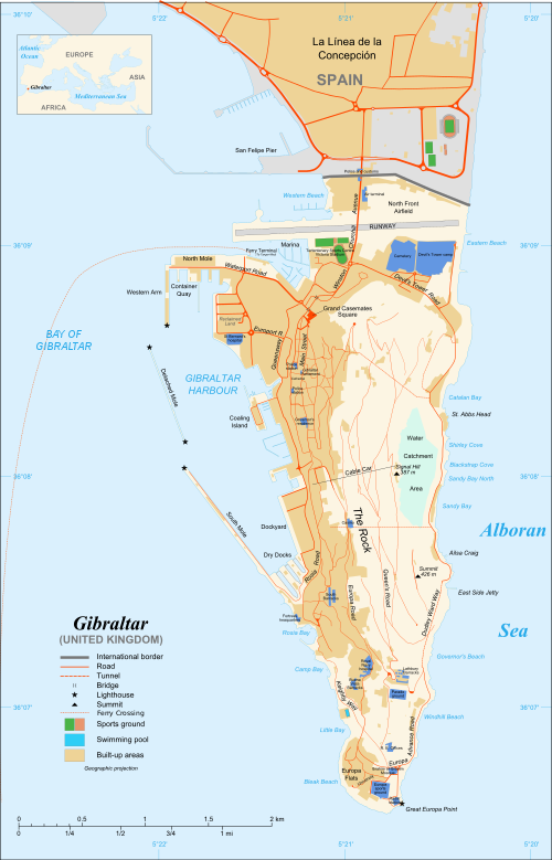
File:Gibraltar map-en-edit2.svg
Captions
Captions
Summary
[edit ]
Wikipedia
If you think this file should be featured on Wikimedia Commons as well, feel free to nominate it.
If you have an image of similar quality that can be published under a suitable copyright license, be sure to upload it, tag it, and nominate it.
| Camera location | 36° 08′ 00′′ N, 5° 21′ 00′′ W Kartographer map based on OpenStreetMap. | View this and other nearby images on: OpenStreetMap | info 36.133333; -5.350000 |
|---|
Map created using screenshots of Google Earth satellite imagery from a point of view located at 1.18 km of altitude (available imagery of November 2007);
Other references:
- Locator map: Image:Blank map of South Europe and North Africa.svg (modified) created by Historicair
Approximate scale: 1:40,000 (accuracy: about 10 m) - Note: The roads width is proportional to reality
- Carte créée à partir de captures d'écran d'images satellite de Google Earth d'un point de vue placé à 1,18 km d'altitude (imagerie disponible de novembre 2007) ;
- Références complémentaires :
- Carte de la CIA ;
- Carte de Gibnet ;
- Carte du Ministère de la Défense britannique ;
- Carte de localisation : Image:Blank map of South Europe and North Africa.svg (modifiée) crée par Historicair ;
- Échelle approximative : 1:40 000 (précision : environ 10 m) ;
- Note : Largeur du tracé des routes proportionnelle à la réalité ;
(Reusing this file) Attribution and Share-Alike required
Licensing
[edit ]
attribution share alike
- You are free:
- to share – to copy, distribute and transmit the work
- to remix – to adapt the work
- Under the following conditions:
- attribution – You must give appropriate credit, provide a link to the license, and indicate if changes were made. You may do so in any reasonable manner, but not in any way that suggests the licensor endorses you or your use.
- share alike – If you remix, transform, or build upon the material, you must distribute your contributions under the same or compatible license as the original.
File history
Click on a date/time to view the file as it appeared at that time.
| Date/Time | Thumbnail | Dimensions | User | Comment | |
|---|---|---|---|---|---|
| current | 16:36, 5 April 2017 | Thumbnail for version as of 16:36, 5 April 2017 | 1,000 ×ばつ 1,558 (1.46 MB) | RaviC (talk | contribs) | + University, Ferry terminal (& Route), Cathedral |
| 18:52, 11 December 2007 | Thumbnail for version as of 18:52, 11 December 2007 | 1,000 ×ばつ 1,558 (1.79 MB) | Jeff Dahl (talk | contribs) | resized 1200 down to 1000px wide, minor label fixes | |
| 17:08, 10 December 2007 | Thumbnail for version as of 17:08, 10 December 2007 | 1,200 ×ばつ 1,870 (1.78 MB) | Jeff Dahl (talk | contribs) | {{inkscape}} {{Location|36|08|00|N|5|21|00|W|type:city_scale:50000}} {{Information |Description=Map in English of Gibraltar |Source=adapted from: Image:Gibraltar map-en.svg <br/>Map created using screenshots of [[:en:Google Ea |
You cannot overwrite this file.
File usage on Commons
The following 38 pages use this file:
- User:Veritas Sapientiae/Commons:Translation possible/Tìm hiểu thêm
- Commons:Translation possible/Ajuda
- Commons:Translation possible/Aprenda mais
- Commons:Translation possible/Aprende más
- Commons:Translation possible/Dowiedz się więcej
- Commons:Translation possible/Learn more
- Commons:Translation possible/Learn more/tr
- Commons:Translation possible/Mehr erfahren
- Commons:Translation possible/Para saber máis
- Commons:Translation possible/Per saperne di più
- Commons:Translation possible/Saznajte više
- Commons:Translation possible/Дознајте повеќе
- Commons:Translation possible/Дізнайтеся більше
- Commons:Translation possible/اطلاعات بیشتر
- Commons:Translation possible/了解更多
- Commons:Translation possible/詳情
- Commons:Translation possible/詳細
- Commons:Translation possible/더 보기
- File:Gibraltar map-HE.svg
- File:Gibraltar map-de.svg
- File:Gibraltar map-en.svg
- File:Gibraltar map-es.svg
- File:Gibraltar map-fr.svg
- File:Gibraltar map-hu.svg
- File:Gibraltar map-it.svg
- File:Gibraltar map-mk.svg
- File:Gibraltar map-ms.svg
- File:Gibraltar map-pl.svg
- File:Gibraltar map-uk.svg
- File:Gibraltar map-ur.svg
- File:Gibraltar map (claimed isthmus)-es.svg
- File:Gibraltar map (non Utrech territories)-es.svg
- File:Gibraltar map (reclaimed land)-es.svg
- File:Xibraltarplano-en.jpg
- File:Xibraltarplano-es.jpg
- File:Xibraltarplano-es cut.jpg
- File:Xibraltarplano-gl.jpg
- Template:Other versions/Gibraltar map
-es.svg)
-es.svg)
-es.svg)
File usage on other wikis
The following other wikis use this file:
- Usage on af.wikipedia.org
- Usage on ar.wikipedia.org
- Usage on av.wikipedia.org
- Usage on azb.wikipedia.org
- Usage on bg.wikipedia.org
- Usage on bn.wikipedia.org
- Usage on bs.wikipedia.org
- Usage on ceb.wikipedia.org
- Plantilya:Location map Gibraltar
- Signal Hill
- White Rock
- Sandy Bay
- Roca Blanca
- Ailsa Craig
- Passage Point
- El Peñón
- The Rock
- Middle Hill
- Gibraltar (pagklaro)
- Rock of Gibraltar
- Deadmans Beach
- Eastern Beach
- Western Beach
- Punta Pasaje
- Punta Europa
- La Roca
- Governor’s Beach
- Camp Bay
- Europa Point
- Gibraltar Bay
- Cerro de Enmedio
- Blackstrap Bay
- Caledonian Canal
- Great Europa Point
- Gibilterra
- White Rock (bato sa Gyibraltar)
- Western Beach (lapyahan sa Gyibraltar)
- Signal Hill (bungtod sa Gyibraltar)
- Sandy Bay North
- Sandy Bay (luuk)
- Saint Michael's Cave
- Saint Abb's Head
- North Gorge
- Middle Hill (bungtod sa Gyibraltar)
- Mediterranean Steps
- Martin's Cave
- Europa Point (punta sa Gyibraltar)
- The Lido
- Levant Cave
- H.M.S. Rooke
View more global usage of this file.
Metadata
This file contains additional information such as Exif metadata which may have been added by the digital camera, scanner, or software program used to create or digitize it. If the file has been modified from its original state, some details such as the timestamp may not fully reflect those of the original file. The timestamp is only as accurate as the clock in the camera, and it may be completely wrong.
| Width | 1000 |
|---|---|
| Height | 1558.2777 |